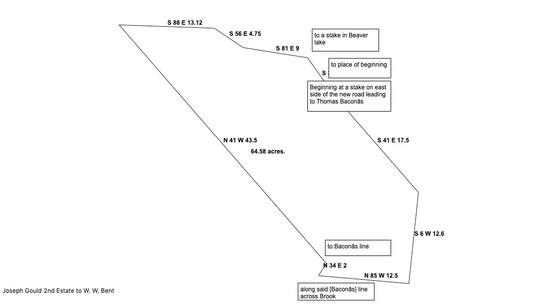
Joseph Gould 2nd (1802-1855) was a son of Jedore Gould, one of the original Acadian tenants of J. F. W. DesBarres. Joseph had inherited a half-interest in the lease held by Jedore Gould, and he later purchased several of these properties from Augustus DesBarres. One of the properties Joseph purchased in 1838 was a 67-acre lot bordered northerly by Beaver Lake, westerly by the heirs of Francis Gould, and easterly by the Roach Line dividing Joseph's property from the homestead of William Keiver. (Deed Book P, p. 118). The Roach Line was a survey line run sometime around 1816 and said to be the dividing line between DesBarres's properties on the old Gmelin Grant and Amherst Township.
Originally I had assumed that the Roach Line was just one more variation of the Gmelin Line. However, subsequent sales of Joseph Gould's property show that the Roach Line lay to the east of the original Gmelin Line.
Following Joseph's death in 1855, his widow Mary (Curan) and agent Alfred Atkinson sold 62 acres of the 67-acre property. (Deed Book AA, p. 392). This property was bisected by a newly-made road to Thomas Bacon's place, and its southern border ran along Bacon's property.
Thomas Bacon had married Ann (Harrison), the widow of David Keiver who died young in 1832. Thomas was appointed guardian of their children until the children had all turned 21. The family lived on the 100-acre portion of wilderness Lot 1 that David Keiver had purchased from John Stuart in 1840. (Deed Book Q, p. 43). Thomas Bacon also owned the 45-acre triangular tip of the 1816 Samuel McCulley grant known as the "extreme gore", which adjoined the 100-acre lot on the west. A few years after Ann's death, Thomas and his second wife Matilda (Smith) sold both lots to Thomas Shipley (Deed Book DD, p. 17).
According to the deeds, Thomas Bacon's property formed the southern boundary of Joseph's property, which ran along the Bacon property N 85 degrees W for 12 1/2 chains. This is very interesting because Bacon's 100-acre lot lay east of the tip of the adjoining 1816 McCully grant. The eastern border of the McCully Grant, with a bearing of N 45 W, was the Amherst Township Boundary otherwise known as the Gmelin Line. This means that at least some portion, if not all, of Joseph Gould's 62-acre property also lay east of the original Gmelin Line. Joseph's eastern boundary, the Roach Line, divided his property from the estate of Michael Keiver. This is clear evidence that the Roach Line was east of the Gmelin Line and that Gould properties also extended east of the Gmelin Line.
This raises many questions. Did a new settlement regarding the Gmelin Line extend DesBarres's boundaries? Did DesBarres acquire additional properties that extended his line? At present I have found no evidence that DesBarres purchased any additional properties. I will definitely keep working on this mystery. In the meantime, I have made a few updates to the The Gould Properties page of this website.
 RSS Feed
