Cumberland County Maps
|
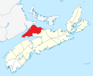
Robert Ripley, Isabella Beane and family settled in the British colony of Nova Scotia in what is now Cumberland County, Nova Scotia. In your research, you will soon encounter place names such as Amherst, Fenwick, Maccan, Nappan, Springhill, and River Philip. Paying close attention to these place names on birth, marriage, death, and burial records often helps to sort out family relationships. The Map and Place Names Guide on the Cumberland County Geneaological Society website is very useful in learning their locations and the origins of the place names.
The Tantramar Marsh refers to the tidal saltmarsh which borders the Bay of Fundy. The Isthmus of Chignecto is a narrow strip of land between Nova Scotia and New Brunswick which joins Nova Scotia to the mainland of North America. |
|
|
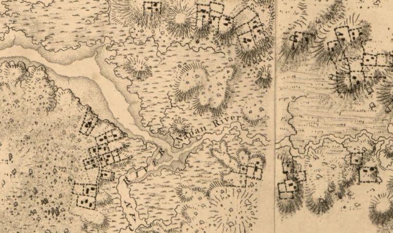
Frederick Wallett DesBarres made several early maps of the Chignecto area. Many of his maps are viewable and downloadable from the Leventhal Map & Education Center online. His 1777 map of Chignecto shows early settlements in Amherst, Menudie, Maccan, and Nappan. Click the plus sign on the map to enlarge it.
|
|
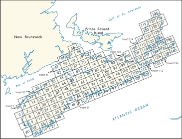
Crown Land Index maps of Nova Scotia, which show the original land grants, are available for online viewing, download, and purchase at the Nova Scotia Department of Natural Resources website. Maps 59 and 60 are particularly useful for researching the Ripley Land Grants.
|
An 1873 map of Cumberland County drawn by A.F Church is also available for purchase. This map shows locations of various residents and includes Business Directories for many of the communities in Cumberland County which list the residents' occupations. The directories are posted online at the Cumberland County Gen Web page.
Amherst Township Maps at Historical Maps of Nova Scotia Archives Online
If you go to the Nova Scotia Archives website and find their Historical Maps of Nova Scotia section, you can search by community name. A search for "Amherst" returns 14 maps of Amherst including a stunning watercolour version with very clear lot numbers based on a 1764 map. A search for "Cumberland" returned many maps including an 1860 Cumberland Grant map that shows residents of Amherst, Maccan, Nappan, Fenwick and other communities.
If you go to the Nova Scotia Archives website and find their Historical Maps of Nova Scotia section, you can search by community name. A search for "Amherst" returns 14 maps of Amherst including a stunning watercolour version with very clear lot numbers based on a 1764 map. A search for "Cumberland" returned many maps including an 1860 Cumberland Grant map that shows residents of Amherst, Maccan, Nappan, Fenwick and other communities.
Ernest Coates Map File
If you visit the Cumberland County Genealogical Society in Amherst, you may want to look at the Maps File in the Ernest Coates Collection. Here you will find a collection of early plans and drawings, many by Charles Baker, which show the locations of various lots and grant properties in Amherst, Maccan, and Fenwick.
If you visit the Cumberland County Genealogical Society in Amherst, you may want to look at the Maps File in the Ernest Coates Collection. Here you will find a collection of early plans and drawings, many by Charles Baker, which show the locations of various lots and grant properties in Amherst, Maccan, and Fenwick.
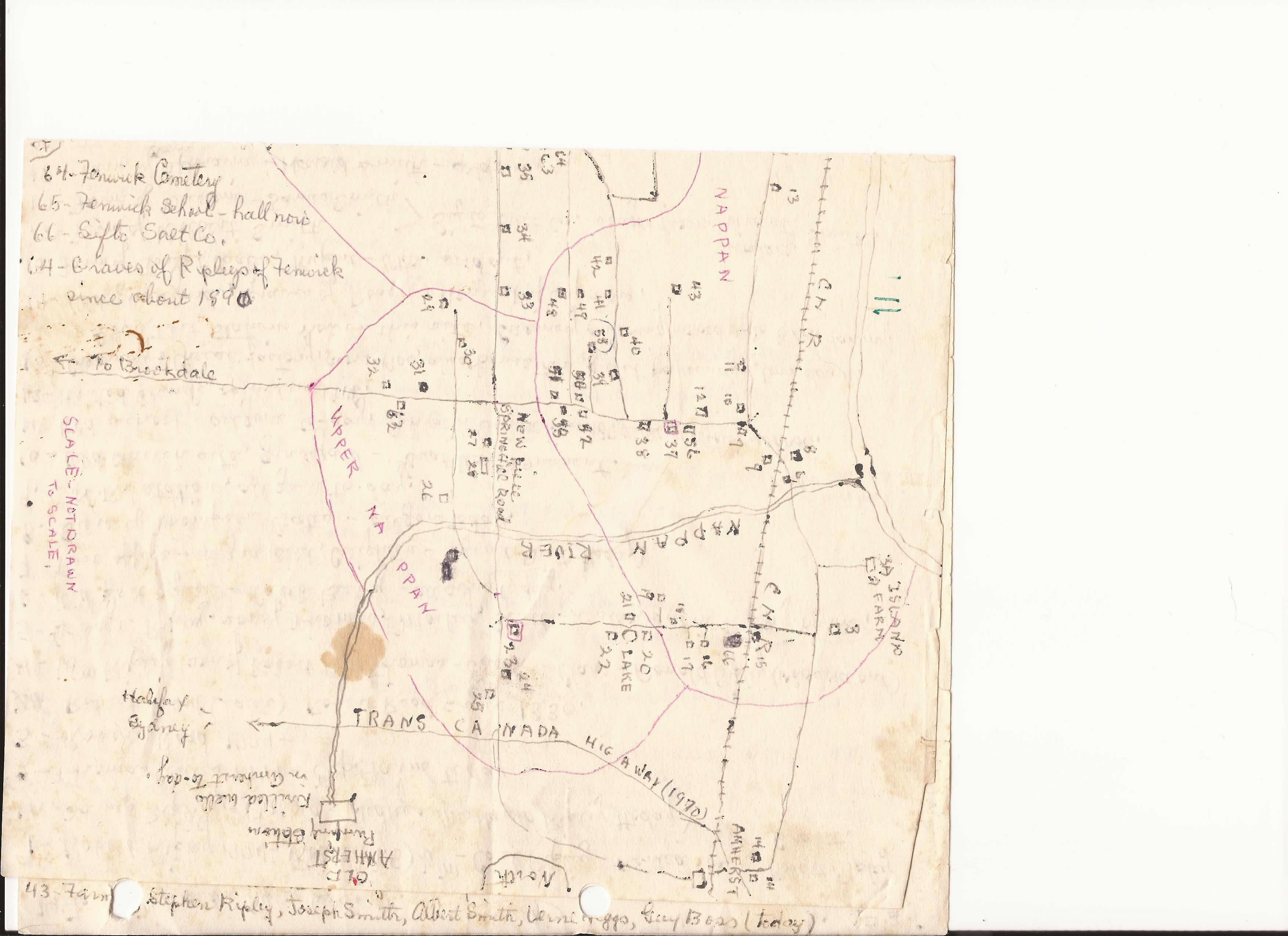
Ernest Coates Map of Homesteads in Amherst, Maccan, Nappan, and Fenwick
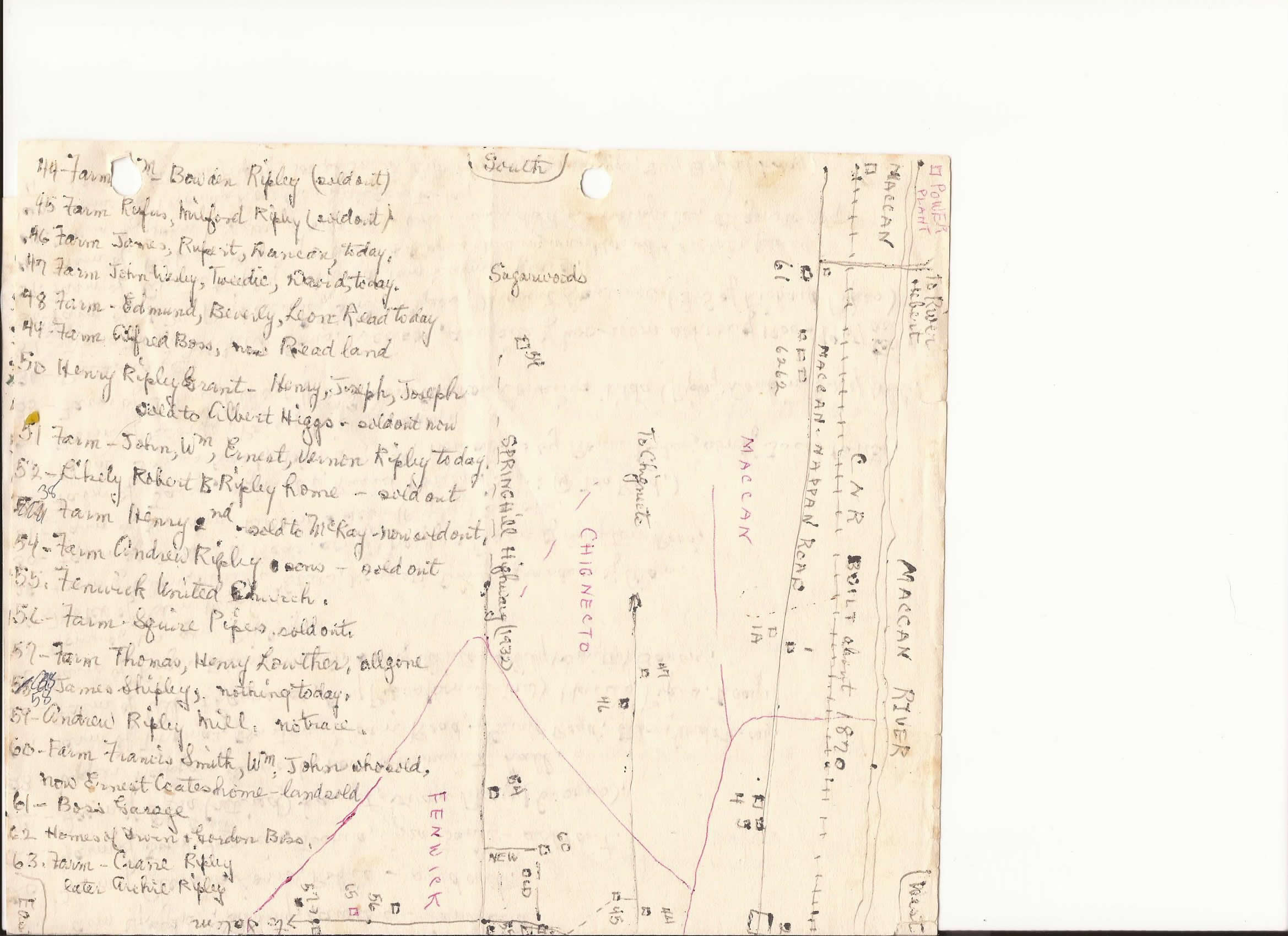
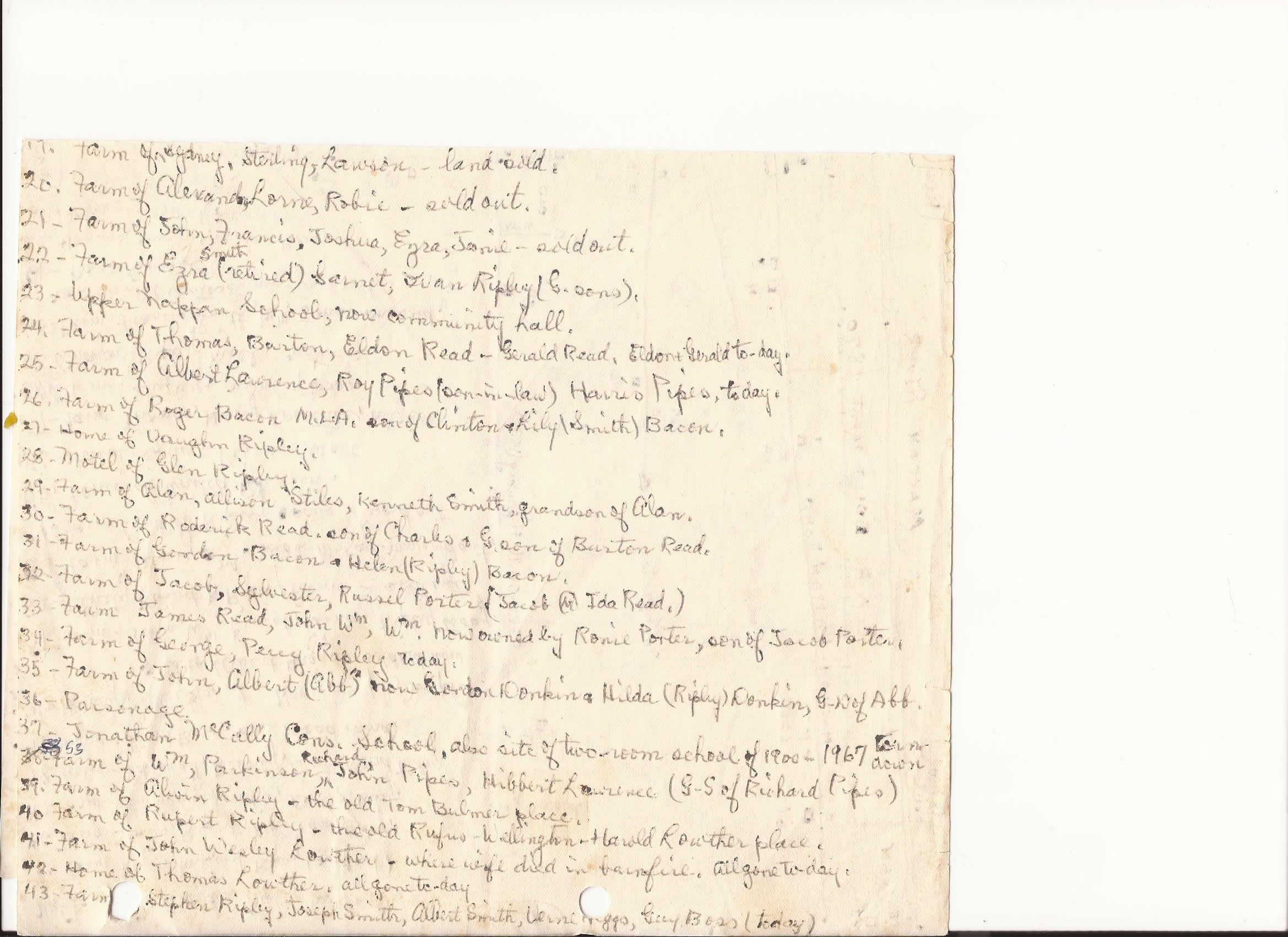
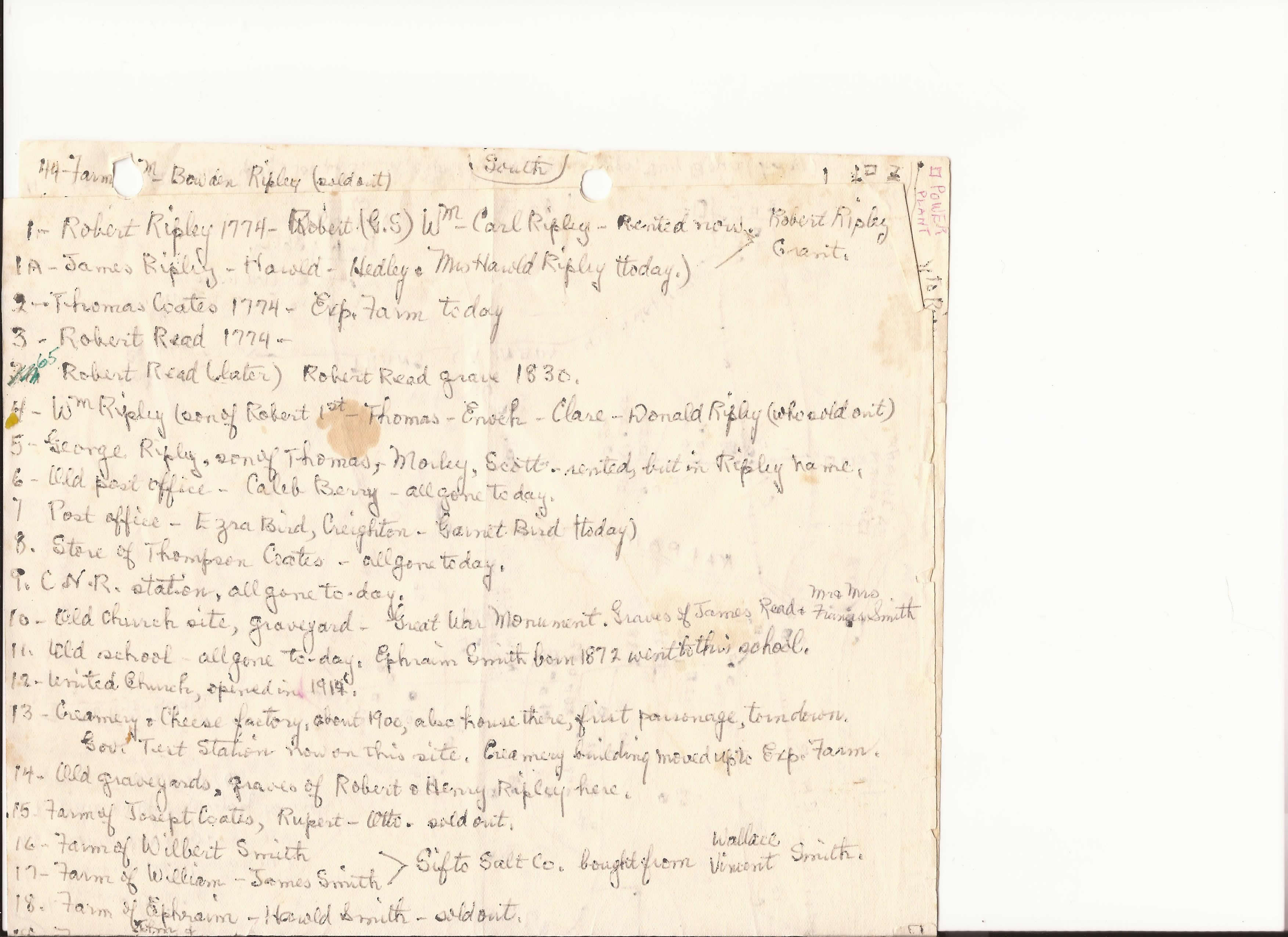
A few years ago Gord Ripley gave me a copy of a hand-drawn map that Ernest Coates had given to him during a visit to the Amherst area in the 70's. The map shows the location of many of the original homesteads and lists their subsequent owners. The map has been of great help to me, and it is mentioned often in my discussions of homesteads on this website. Gord has kindly given me permission to share the map which Ernest so generously shared.
A few years ago Gord Ripley gave me a copy of a hand-drawn map that Ernest Coates had given to him during a visit to the Amherst area in the 70's. The map shows the location of many of the original homesteads and lists their subsequent owners. The map has been of great help to me, and it is mentioned often in my discussions of homesteads on this website. Gord has kindly given me permission to share the map which Ernest so generously shared.
| map_001.jpg |
| map_002.jpg |
| map_003.jpg |
| map_004.jpg |
openstreetmap.org
Open Street Map is a free wiki world map created by volunteers. Because it's open source and sometimes created by people with local knowledge, I've found details included on the map that either don't appear or aren't labelled on other maps. There are also layers you can display over the maps that mark features such as marshes and changes of elevation.
Open Street Map is a free wiki world map created by volunteers. Because it's open source and sometimes created by people with local knowledge, I've found details included on the map that either don't appear or aren't labelled on other maps. There are also layers you can display over the maps that mark features such as marshes and changes of elevation.
