Understanding Thomas Cochran's Map
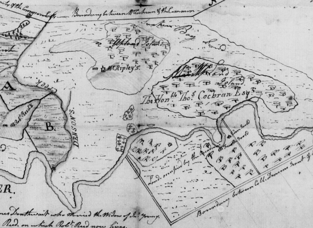
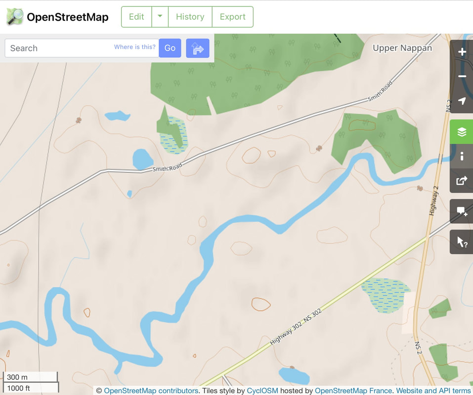
A map of Thomas Cochran's property can be viewed and downloaded online. (DesBarres Papers, Series 5 M.G. 23, F1-5, Vol. 15 Land acquisitions, 1764-1776; Plans, 1765-1916. Document 2911, Reel C-1458 Image 432.). Robert Ripley was leasing the property at the time the map was made, and the map shows where a Mr. Ripley was living. A section of the Cochran map below shows two islands north of the Nappan River. Mr. Ripley lived on the westernmost island. The Open Street Map view of the same area, shows these two islands outlined in brown contour lines near today's Smith Road.
|
|
A Mr. Ripley is indicated on the map north of the Nappan River. This was likely the home of Robert Ripley and Isabella Bean, who had leased the 1000 acres from Robert Fletcher and then from Cochran from 1782-1803. Mr. Ripley's house was on an "Island", a local term for a hill or dry raised area within a marshy area. According to the map, Mr. Ripley's place lay south of the boundary with the Amherst Common Lots but well east of Young's Island and Amherst lot 24, the AA and BB divisions on Cochran's Map. The island was west of today's Hwy 2 and north of the Nappan River opposite Henry Ripley's homestead on the other side. For more information on the possible location of the island, see Francis Caleb Smith on this website.
In order to follow the remainder of the discussion, please download the full version of Cochran's map.
Thomas Cochran had acquired Henry Denny Denson's 1000-acre grant in Amherst in 1784, but for the next hundred years, deeds still referred to the property as the Denson Tract. James Douthwait, shown on Cochran's map, died in 1792, so the map was made before then. In addition, a letter written by a surveyor to J. F. W. DesBarres in 1792 mentions Cochran's Survey. Cochran's map includes much information pertaining to 3 land disputes active at the time. It appears to be a map constructed with a legal agenda in mind.
What I noticed first about Cochran's map was its focus on the marsh lots. The upland lots which made up most of the 1000 acres of Denson's grant are off to the east on the map with a note about them stretching to Cobequid road, but the marsh lots seem to be where the action is. This makes sense as early settlement tended to occur near rivers first.
The map shows a boundary line coming from Cobequid Road (today's Hwy 204) on the northeast at S 62 degrees West, just as Josiah Throop reported in his original survey of the land. When the properties were devised to Cochran's heirs in 1826, that line was coming in from Cobequid Road at S 64 degrees 30" W, forming the northern boundary of the Upland Lots. And by 1888, a map of the estate of James K. Noiles shows the Denson Line at N 67 E. (Nova Scotia Probate Records 1760-1993, Estate Files 1764-1938, no 1483-1534 (M-N), image 126). However, the angle of the line east of today's Hwy 2 may have been different than the line west of Hwy 2.
Cochran's map shows a boundary between Cochran's Marsh and marshland granted to Constantine Dougherty. According to Cochran's Map, Dougherty's grant also bordered on the Amherst Common marsh lots. Constantine Dougherty was granted the 500 acres known as Lot 23 on 23 May 1767. (Old Book 6, p. 667). However, a note on that deed indicates that the land was escheated back to the crown 5 May 1773. On 9 May 1773, Lot 23 was re-allocated to Henry Denny Denson. (Old Book 10, p. 244) Colonel Henry Denson gave the 500 acres formerly granted to Dougherty and "near or adjoining" his property and "lately escheated and granted to Henry Denny Denson" to his daughter Lucy along with his original 1000-acre grant. (Deed Book 13, p. 330, 1774). Robert Fletcher had sold Lot 23 to Stephen Read and Thomas Coates prior to selling the original 1000 acres to Cochran. Fletcher's deed to Cochran only mentioned the original 1000 acres granted to Henry Denny Denson, not the 500-acre Lot 23. So it's unclear why Constantine Dougherty is mentioned on the map.
A boundary with the Amherst Township Common Lots is indicated on the Cochran map with the notation "marshland laid out in two acre common lots". Cochran battled the residents of Amherst for years over the ownership of these lots. See Amherst Common Lots Dispute on this website.
The map also shows Denson’s Creek, Cochran’s marsh, and two other Amherst Township lots north of the Nappan River marked as AA and BB. According to the map, these properties (Amherst Lot 24) were occupied by James Douthwait and Stephen Read, who happened to be the plaintiffs for the Township of Amherst in the Gmelin line dispute. Cochran had his own dispute with Stephen Read and James Douthwaite over 135 acres as indicated in a notation at the bottom of the map. See Marsh Lots 70-75, Stephen Read, and James Young and James Douthwait on this website for details.
Cochran's map also shows a boundary with Amherst's 100-acre lots. This straight boundary line running roughly east/west from Cobequid Road to the OxBend on the Nappan River was a little north of today's Nappan Road east of Hwy 2. However, Cochran has the line drawn much further south. The westernmost of the 100-acre lots were the subject of a dispute between J. F. W. DesBarres's Acadian tenants Francis and Jedore Gould and the Township of Amherst, plaintiffs Douthwait and Read, over the location of the Gmelin line. After a 1792 court decision in their favour, Douthwait and Stephen Read ejected DesBarres’s tenants Francis and Jedore Gould. The Goulds were reinstated by a favourable court decision in 1796. The Acadians Francis and Jedore Gould were shown living on land south of the Nappan River on Cochran’s map.
Cochran was well aware of the Gmelin line dispute; in fact J.F.W. DesBarres first learned of the dispute when Cochran visited him in London. During the visit, Cochran offered to buy the disputed lots. It's puzzling that Cochran included those properties on his map as they were already in dispute between DesBarres and the Township of Amherst and later sold by Augustus DesBarres to the Goulds. Perhaps Cochran also claimed the area or this was his proposal for the property he wanted to purchase from DesBarres. Cochran also tried to purchase the disputed lots from the plaintiff for Amherst Township in the case. By purchasing the properties from both disputing parties, he would have nullified the dispute.
