Robert Ripley and Henry Ripley: The Yorkshire Land Grant 1785
|
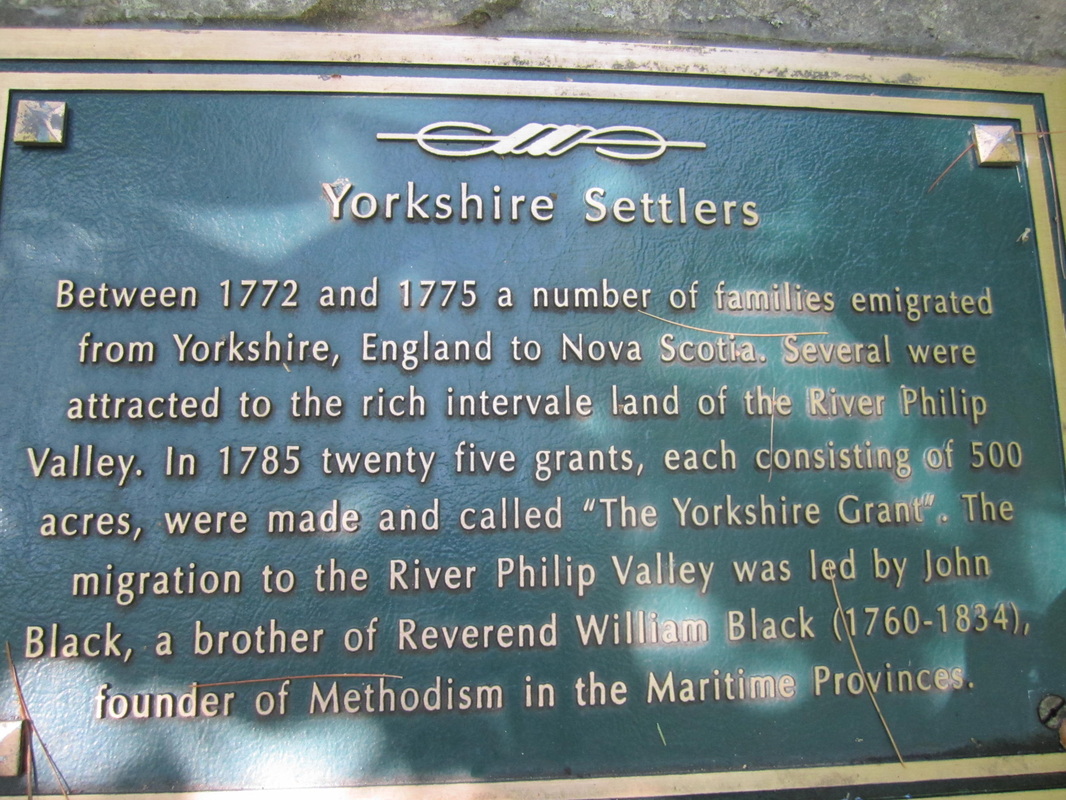
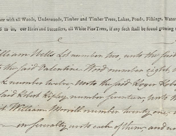
Robert Ripley and Henry Ripley requested land grants in a 1785 petition known as the Yorkshire Grant. Under this grant, 25 settlers from Yorkshire received 500-acre parcels in the River Philip Valley. Henry and Robert were granted lots 16 and 17.
Since Lot 17 was later sold by Robert Ripley and his wife Isabella, the Robert mentioned in the petition must have been the elder Robert, who was 51 years of age in 1785. Son Henry was 23. |
|
|
It is possible to view the original draft petition and supporting documents online at the Nova Scotia Land Papers archive. You can also read about the Grant Process and order copies of the originals. The Ripley names are included on the Donkin 1785 grant (Survey Order #1785-50). It takes a bit of time for the original documents to load. When you click on the links it looks like nothing has changed; you have to scroll down on the page to view them. The Draft Petition is particularly interesting as it lays out the improvements that must be done to the property including one good house 16 x 20 feet.
|
A plaque commemorating the Yorkshire Grant can be found a few feet away from the River Philip United Church. The photographs below were taken during a July 2013 visit. A sign at the base of the rock indicates that more history of the area is available in the church but I was not able to visit at that time.
In July of 2014 I re-visited the River Philip United Church site with Ripley descendants Clair Ripley and his niece Eleanor Ripley. As long-term residents of the area and descendants of John Ripley, son of the original Robert Ripley and Isabella Beane, they are very knowledgable about the River Philip Ripleys. We met inside the church to share a variety of research materials from Yorkshire and Cumberland County. Then Clair and Eleanor treated me to an information-packed tour of River Philip and Collingswood Corner including the Williamsdale and Collingwood Wyvern Cemeteries. For a deep dive on the location of the church, see River Philip United Church on this website.
Location of the plaque
According to the Yorkshire Settlers 1772-1775 website, the plaque commemorating the Yorkshire Settlers is located at GPS location 45.660000 -63.906111. I found these coordinates to be accurate. The Yorkshire Settlers 1772-1775 website also says the location is 50 m (metres) south of the River Philip United Church. Take Highway 104 southeast from Amherst to the Oxford Exit number 6. Head south toward Oxford Junction and Collingwood on Wyvern Road, not north to Oxford. The church is located at 2808 Wyvern Road. When you drive from Oxford to Collingwood Corner, you are driving through the 25 Lots that were allocated in the Yorkshire Grant.
According to the Yorkshire Settlers 1772-1775 website, the plaque commemorating the Yorkshire Settlers is located at GPS location 45.660000 -63.906111. I found these coordinates to be accurate. The Yorkshire Settlers 1772-1775 website also says the location is 50 m (metres) south of the River Philip United Church. Take Highway 104 southeast from Amherst to the Oxford Exit number 6. Head south toward Oxford Junction and Collingwood on Wyvern Road, not north to Oxford. The church is located at 2808 Wyvern Road. When you drive from Oxford to Collingwood Corner, you are driving through the 25 Lots that were allocated in the Yorkshire Grant.
Sources and other information:
Barkhouse, Andrew P. All Mines and Great Pines: A History of Burials in River Philip, Nova Scotia., 1998 and 2000. This self-published book was given to me on my July 2014 trip by Eleanor Ripley-Barrow. I believe it is available for sale at the Cumberland County Museum in Amherst. The 20 page book includes a bit of history on the Yorkshire Land Grant, the early Methodist leaders and churches including the church at River Philip, and information about the Methodist cemetery at River Philip. Information about the symbolism on the gravestones is particularly interesting.
Historic Places website gives further information about the River Philip United Church.
Keating, Murray L. Cemeteries of Cumberland County: River Philip, Collingwood-Wyvern, Williamsdale, Millvale, Rose. I purchased my copy of this book of cemetery transcriptions at the Cumberland County Genealogical Society. It will be very helpful to descendants of the original Robert Ripley through his son John.
Photographs of the plaque and George Oxley's grave are also available online at the Yorkshire Settlers 1772-1775 website.
