Fenwick Crossroads Lots
J. F. W. DesBarres died in 1824, and his son Augustus DesBarres continued to sell properties to tenants and heirs of tenants still holding leases. He also began to sell lots in what is now Fenwick. The west section of lots lay southwest of the intersection of today's Hwy 2 and Fenwick Road. The east section of lots lay between Hwy 2 and the Gmelin line, the west boundary of the Samuel McCully Grant. The McCully grant lay in the triangular area where the original Gmelin Line and Amherst Township Line diverged. (See 1816 Samuel McCully Grant on this website for details.)
In Fenwick 1778-1978, Myrtle Chappell describes the homesteads and current owners of many of these properties. The Ernest Coates Map File at Cumberland County Genealogical Society contains several drawings Ernest made of this area, specifically 05050.05.M03 H 36, 50, and 51.
In Fenwick 1778-1978, Myrtle Chappell describes the homesteads and current owners of many of these properties. The Ernest Coates Map File at Cumberland County Genealogical Society contains several drawings Ernest made of this area, specifically 05050.05.M03 H 36, 50, and 51.
Fenwick Lots west of Highway 2
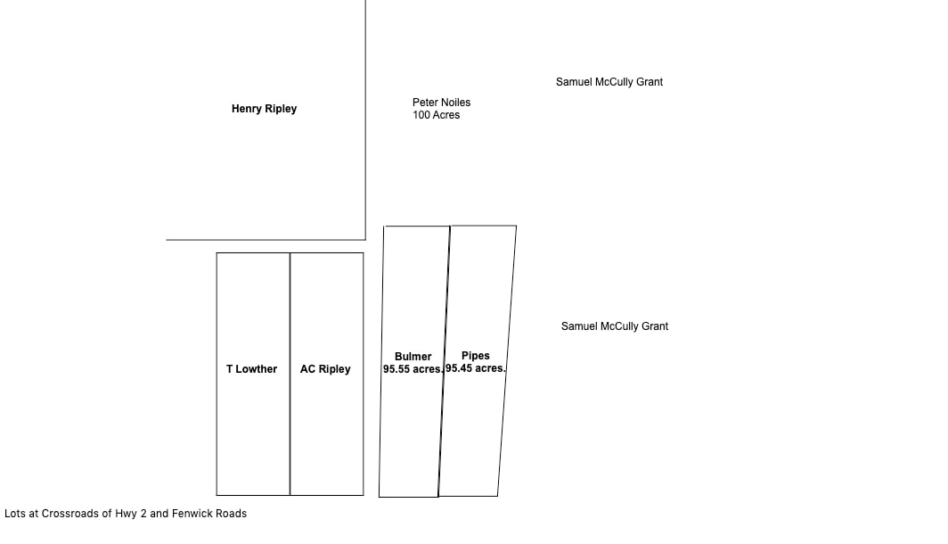
Although I say the first bank of lots lay south of today's Fenwick Road and west of Hwy 2, neither road existed at the time the lots were sold. In 1834, my 2nd great grandfather Andrew C. Ripley purchased 100-acre lot 5 from Augustus DesBarres. Hwy 2 ran along the east side of Andrew's lot. The lot was bordered on the north by Henry Ripley. The original deed and survey of Henry's property show that his southeast corner was formed by a line that ran north/south 60 chains and another line that ran east/west 47 chains. (Deed Book M, p. 253). Also see Andrew C. Ripley and Elizabeth Pipes: The Home Place and Homestead of Henry Ripley and Mary Fawcett on this website.
At the time of sale, many of the lots were identified only by the lot number "according to a plan made by William Baker". However, later sales stated the dimensions of these lots. The lots typically ran 17 chains 40 links at their north and south boundaries and 57 chains and 25 links on their east and west boundaries. Originally these boundaries ran due north, south, east, and west. However, they later shifted to an 88 degree angle on the north and south boundaries and 4 to 8 degrees on their west and east boundaries. There were two rows of lots separated by a road that ran east/west. The south row bordered on the rear line of the DesBarres Nappan Tract. Only Andrew Ripley's Lot 5 and Thomas Lowther's Lot 6 are shown below. Additional lots from this bank were pictured in a blog post. fenwick-road-and-hwy-2-crossroads.html
1836 DesBarres to Bulmer (East of Hwy 2)
On 3 May 1836, Augustus DesBarres sold side-by-side lots to William Bulmer and William "Squire" Pipes, identified as parts of lots 35,36, and 37 on the Baker Plan. William Bulmer's lot began on Mr. Ripley's line and ran due east 15 chains 21 links, then ran due south 2.5 degrees 64 chains, then due west 14 chains 10 links to Andrew Lowther's [ sic] line. Bulmer's line then followed Andrew's line and Mr. Ripley's line north 1 degree east 44 chains [sic]. This dimension must be 64 chains to match the east side. Bulmer's lot was 64 chains long and Andrew Ripley's lot was only 57 chains and 25 links long so Bulmer's lot would have to extend longer than Andrew's. I'm assuming that "Mr. Ripley" is Henry Ripley in this deed as Andrew's property was bordered on the north by Henry Ripley. (Deed Book N, p. 463). I have sometimes wondered whether Andrew Ripley might be the illegitimate son of Henry Ripley's daughter Mary who was married to Thomas Lowther. So it was interesting that the person who transcribed this deed referred to Andrew Ripley as Andrew Lowther. On the other hand, the transcriber may simply have become confused, because Thomas Lowther was Andrew's neighbour to the west.
In 1842, Bulmer sold the 95-acre lot to R. K. Smith (Deed Book R, p. 88). In 1846, Smith sold to Charles Baker (Deed Book S, p. 692), and in 1869, Baker sold the 100-acre lot to George A. Dickinson who homesteaded on the property (Deed Book PP, p. 192). The property was "bounded on the east by land occupied by William Pipes Esq. on the south by a road leading to the residence of the widow of the late Thomas Holt on the west by the road leading to Amherst and on the north by land owned by William Bird."
George Dickinson died without leaving a will, but in 1907, the siblings of Frank Roberto W. Dickinson relinquished their interest in the property to "Bert" (Deed Book 84, p. 457).
According to Myrtle Chappell, this property went next to Elmer Ripley and his wife Lauris Florence. Elmer Ripley also acquired the neighbouring Pipes lot.
1836 DesBarres to William Squire Pipes (East of Hwy 2)
In 1836, DesBarres sold William "Squire" Pipes a 100-acre lot that lay to the east of Bulmer's.
William Pipes's lot began at the West [sic] corner of Bulmer's and ran east 15 chains and 21 links, then south 4 degrees 64 chains, then due west 14 chains and 10 links, and then, following Bulmer's line, north 2.5 degrees east 64 chains. The Pipes lot bordered on the Gmelin Line, its shared boundary with Samuel McCully's grant. (Deed Book N, p. 360).
In 1858, William "Squire" Pipes sold the property to his brother Jonathan Richard Pipes on the condition that if William, his executrix or heirs repaid the purchase price of 122 pounds and 8 shillings, the sale would be considered null and void (Deed Book AA, p. 478). The heirs must have done so, because in 1887, William Pipes and his second wife Phoebe, sold the property to William's son John Parkinson Pipes for one dollar (Deed Book 17, p. 348). In 1888, John Parkinson Pipes and his wife Martha sold the property to John's sister Lucy and her husband James C. Smith for one dollar (Deed Book 22, p. 631). In 1896, James C. Smith and his wife Lucy sold the property to Clarence Dickinson (Deed Book 48, 322). Elmer Ripley, who had previously purchased the neighbouring Bulmer Lot, acquired the Pipes lot in 1969. (Deed Book 258/558).
The Fenwick school house at 921 Fenwick road, also used as community hall, was originally located on the northwest side of the Pipes property but has been moved a short distance to the east side of the lot. According to Myrtle Chappell, the Gmelin Line ran past the east side of the building.
Since George A. Dickinson homesteaded on the north side of Fenwick Road, and the schoolhouse and Pipes homestead were also on Fenwick Road, we know that Fenwick Road ran through the northern section of these lots. It's not possible at this time to determine exactly how these lots lined up relative to Andrew Ripley's lot, Hwy 2 and Fenwick Road, so the drawing only shows their relative positions.
In 1842 DesBarres to Peter Noiles
In 1842, Augustus DesBarres gave Peter Noiles two properties in Fenwick in exchange for any claims on the property on which he was then living in Nappan. One of the Noiles properties was 100-acre Lot 13 in the bank of lots southwest of today's Fenwick Road and Hwy 2. The other was a lot north of the Bulmer and Pipes lots. That lot was bounded on the west by John Ripley, on the south by William Bulmer and William Pipes, on the east by John Coates, and on the north by lands conveyed to John Gould and lands conveyed to Lawrence, Joseph, Louis, and George Gould. Unfortunately no measurements were given for the 100-acre lot. (Deed Book Q, p. 465).
Henry Ripley had died prior to 1842 and his son John Ripley had inherited the eastern-most section of Henry's property. That explains why the western boundary of the Noiles property bordered John Ripley. John Coates had purchased the 45-acre "extreme gore" of Samuel McCully's property in 1833, that was the eastern boundary of the Noiles property. John Gould was a son of Jedore Gould, and Lawrence/Joseph/Louis/George were sons of Jedore's brother Francis. The Goulds had leased and later purchased almost all of the property between Henry Ripley and the Keivers on the east. The northeast corner of the Peter Noiles property was either close to or on the point where the Gmelin line changed from a north/south orientation to a 45 degree angle as it ran toward the Nappan River.
The Noiles lot was later sold to William Bird. A map in the Ernest Coates Map file at Cumberland County Genealogical Centre shows a William Bird property north of the Bulmer/Pipes lots described above and bordered on the west by Hwy 2 and east by the large McCully Grant. (Map .05.050.05.MO3 H 36). According to Myrtle Chappell in Fenwick 1778-1978 p. 36-38, William Bird's son Ezra later sold the property William Henry Smith, who passed it to his son John Francis Smith. The property went next to Burton Thomas Read and then to his son Charles, who lived on the property with his wife Freda.
