The Denson Grant 1764 to 1784
1764 Josiah Throop Survey
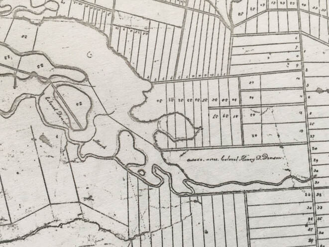
In a deposition made around 1796 regarding a boundary dispute between J.F.W. DesBarres and Amherst Township, Josiah Throop described conducting the original survey for Denson's grant in 1764. Throop testified as follows, "At the head of the marsh I marked an Oak tree on the north west side of the river. Being ordered by the Surveyor General to lay out 1,000 acres of land for Henry Denny Denson Esq. in any part of Amherst he should choose not then being located, I began his tract, the east corner of which I began on the Cobequid Road and ran his line south 62 degrees west as the needle then pointed until I struck a remarkable bow of the River Nappan about 70 chains up the river from the above-mentioned Oak tree. Thence crossing the river, thence down the river it being the line, as will appear by the plan of the Township of Amherst now in the office of Charles Baker." (DesBarres Papers, Series 5 (M.G. 23, F1-5, Vols 22-23): Document 5296, Reel C-1460, Img 343-344).
The "1000 acres Colonel Henry D. Denson" and "Colonel Denson's Marsh" are clearly labeled on the map below. (from Ernest Coates map file). Cobequid Road is today's Hwy 204 that runs through Brookdale. The "remarkable bend" mentioned by Throop became known as the Ox Bend.
1767 Henry Denny Denson Grant
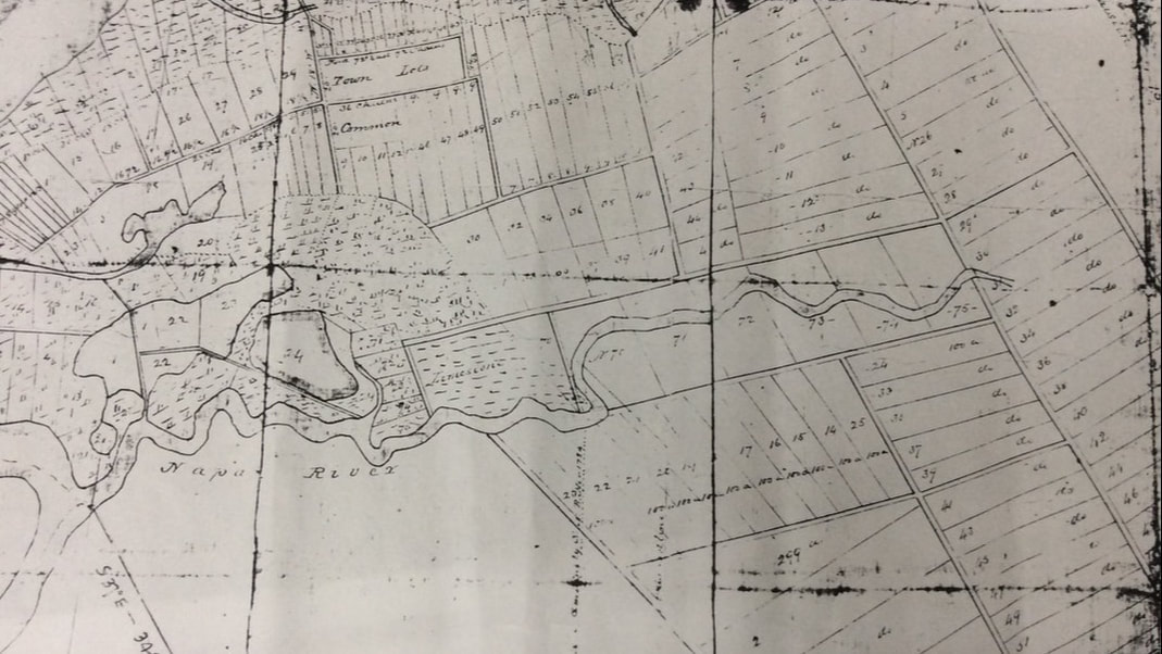
On 5 August 1767, Denson was officially granted the 1000 acres in Amherst Township by Lord William Campbell on advice of His Majesty's Council. The tract included 5 lots of upland numbered 70, 71, 72, 73, 74, and 75 lying on both sides of the Napan[sic] River and five lots of marshland also numbered 70-75 plus an additional 150-acre piece of land known as the Lime Stone Marsh. (Deed Book 6, p. 685 and Deed Book 7, p. 230).
A map of the Amherst Township Lots was among papers donated to the Cumberland County Genealogical Society by the late Susan Hill. The survey map by Chas. Morris (1761?) shows upland lots 70-75 and a Limestone Marsh that straddle the Nappan River. Since the upland lots were in Amherst Township and straddle the Upper Nappan River, they must lie north and east of the Gmelin line in the vicinity of Old Porter Road. If you stand at the intersection of Hwy 2 and Lower Porter Road and look north and east, you are likely viewing some of the upland lots of this 1000-acre property which extended along the Nappan River to the Cobequid Road. The matching marsh lots 70-75 lay west of the Limestone Marsh, north of the Nappan River and west of today's Hwy 2.
1774 Denson to Lucy Fletcher
In September 1774, Henry Denny Denson, his daughter Lucy, her husband Robert Fletcher, and their agent Richard Bulkeley came to an agreement regarding the 1000-acre property on the Nappan River. On 2 May 1768 Henry Denson had attempted to gift the property to his daughter Lucy "before the marriage of said Lucy with said Robert for and in consideration of the love and affection which he bore to the said Lucy his daughter and for her better support and maintenance." However, perhaps because Lucy was a minor at the time, the parties to the agreement had decided to put the property in trust for Lucy in the care of Richard Bulkeley who was tasked with finding a buyer.
In addition to the 1000-acre Denson Grant, Lucy also received 500 acres "near or adjoining" that had been originally granted to Constantine Dougherty and escheated and re-allocated to Henry Denny Denson. (Deed Book 13, p. 30, Document #503170307, Registered 1774 in Halifax County.). Both the original grant to Constantine Dougherty and the re-allocation to Denson describe the 500-acre property as Lot 23 in the Amherst Township. (Grant Book 6, 667 and Grant Book 10, p. 244).
1779 Robert Fletcher to Stephen Read and Samuel Sharpe
On 10 Dec 1779, Robert Fletcher agreed to lease his farm in Nappan, then in possession of Stephen Read, to Samuel Sharpe for the price of 20 pounds per year. The size of the property is not mentioned and it's possible the term was 4 years, but the lease is difficult to read. (Book C, p. 70).
On 10 Dec 1779, Robert Fletcher agreed to lease his farm in Nappan, then in possession of Stephen Read, to Samuel Sharpe for the price of 20 pounds per year. The size of the property is not mentioned and it's possible the term was 4 years, but the lease is difficult to read. (Book C, p. 70).
1801 Robert Fletcher to Stephen Read and Thomas Coates
In 1801 Robert Fletcher sold two marsh properties to Stephen Read, who then resided on or near the mouth of the Nappan River. One of the properties was 22 1/2 acres of marsh and was part of Lot 23. The other was 72 1/2 acres of marsh and adjoined the other lot but it was not clear whether it was part of Lot 23. In 1802, Robert Fletcher sold the remainder of Lot 23 to Thomas Coates. For details see Stephen Read on this website.
In 1801 Robert Fletcher sold two marsh properties to Stephen Read, who then resided on or near the mouth of the Nappan River. One of the properties was 22 1/2 acres of marsh and was part of Lot 23. The other was 72 1/2 acres of marsh and adjoined the other lot but it was not clear whether it was part of Lot 23. In 1802, Robert Fletcher sold the remainder of Lot 23 to Thomas Coates. For details see Stephen Read on this website.
1782 Robert Fletcher to Robert Ripley
In 1782 Robert Ripley leased 1000 acres in Amherst Township from Lucy Denson’s husband Robert Fletcher for a term of 21 years. According to the lease, Robert Ripley was already living on the land and agreed to pay 100 pounds for every 5 years of the lease. The property leased to Robert Ripley was "all that Farm and premises whereon he now lives situate in the Township of Amherst and County aforesaid and granted by Government to Henery Denson Esq...containing 1000 acres more or less." (Deed Book C, p. 206, registered 1784, Cumberland County, Document #503706141).
In 1782 Robert Ripley leased 1000 acres in Amherst Township from Lucy Denson’s husband Robert Fletcher for a term of 21 years. According to the lease, Robert Ripley was already living on the land and agreed to pay 100 pounds for every 5 years of the lease. The property leased to Robert Ripley was "all that Farm and premises whereon he now lives situate in the Township of Amherst and County aforesaid and granted by Government to Henery Denson Esq...containing 1000 acres more or less." (Deed Book C, p. 206, registered 1784, Cumberland County, Document #503706141).
1784 Richard Bulkley to Thomas Cochran
In 1784, Richard Bulkeley, on behalf of Robert and Lucy Fletcher, having located a buyer offering the highest price, sold the 1000 acres previously granted to Henry Denny Denson to Thomas Cochran of Halifax for 300 pounds. Presumably the lease to Robert Ripley continued, as Ripley's place is labeled on a map later made by Cochran, but there is no mention of the lease in the deed. Although the property passed out of the Denson family, deeds referred to the property as the Denson Tract for almost a hundred years. (Deed Book D, p. 169, Document #503706911, Registered 1784, Cumberland County).
In 1784, Richard Bulkeley, on behalf of Robert and Lucy Fletcher, having located a buyer offering the highest price, sold the 1000 acres previously granted to Henry Denny Denson to Thomas Cochran of Halifax for 300 pounds. Presumably the lease to Robert Ripley continued, as Ripley's place is labeled on a map later made by Cochran, but there is no mention of the lease in the deed. Although the property passed out of the Denson family, deeds referred to the property as the Denson Tract for almost a hundred years. (Deed Book D, p. 169, Document #503706911, Registered 1784, Cumberland County).
