Amherst Township vs. DesBarres
1795 MacDonald Reports on the Gmelin Line Dispute
In 1795, when DesBarres's agent Captain John MacDonald visited the DesBarres properties in Maccan and Nappan, he reported that the location of DesBarres' eastern boundary, still known as the Gmelin line, had become the subject of a dispute with the Township of Amherst. Amherst residents Stephen Read and James Douthwait had sued to eject DesBarres' tenants Henry Ripley, Jedore Gould, and Francis Gould. Stephen Read owned shares in Amherst lot 20. Douthwait had married the widow of John Young, who owned shares of lots 22 and 24. In his report to DesBarres, MacDonald described a claim the Township of Amherst had made on the DesBarres properties then occupied by Henry Ripley and the Goulds.
" As far as I could understand the case of these disputed lands for it is not easy to understand from incorrect Informers intricate matters, to which one is an entire stranger: it is as follows. They are called the hundred acre lots joining the upper part of Napan River. They are said to be well worth 200 pounds to purchase them or 10 pounds per annum rent, having good wood & marsh. It would seem the Township of Amherst claims them as being within the limits granted to it, its number of acres being otherwise short. It is also said to be within the limits described in your grant, & that it has been surveyed for you. Amherst however insists upon having the older grant, so that the subsequent conveyance to you were void. Mrs. Cannon has had possession for you these twenty years, but the dispute has been for four of these years. Amherst has had a verdict already for it, but Mrs. Cannon is to have another hearing or trial in the next Trinity Term 1796."
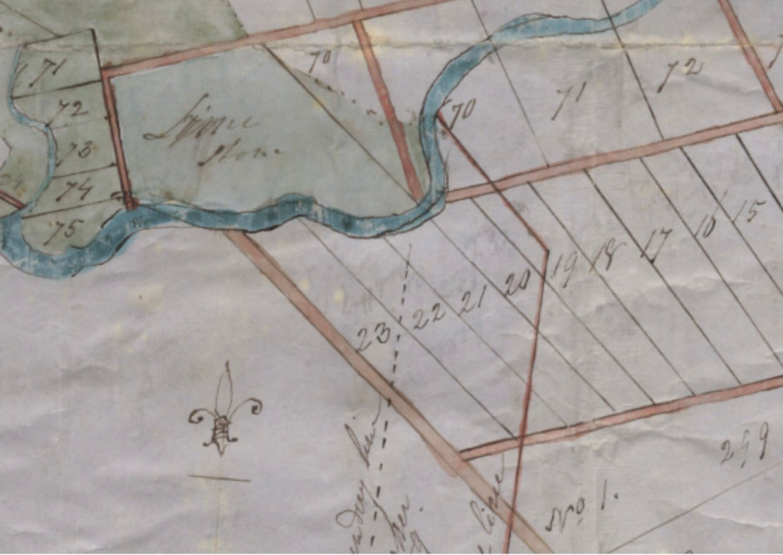
100-acre lots on 1764 plan V7 230 Amherst Township NS Archives Map Collection. Annotations on the map show several alternatives for the Gmelin Line.
|
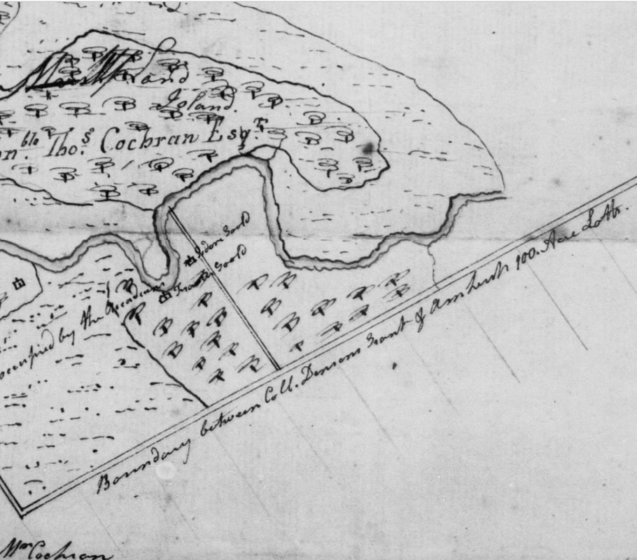
100-acre lots south of Francis and Jedore Gould properties on survey made for Thomas Cochran about 1792.
|
1792 Verdict for Amherst
In a letter dated 29 April 1792, Edward Barron informed Mary Cannon that although no one had appeared to plead her case at court, evidence was nevertheless presented and judgement made that the disputed properties belonged to the Township of Amherst. According to Baron, Canon's tenants had been ejected and possession of the property awarded to plaintiffs Douthwait and Read, mainly on the evidence of surveyor Charles Baker.
Although Mr. Baron stated that Baker's evidence had been "full and clear", he also indicated there had been great confusion about the starting point for the survey. Baron also suggested that when Mr. DesBarres was informed of the judgement he likely wouldn't try to pursue it any further. He obviously didn't know DesBarres very well.
(DesBarres Papers, Series 5 M.G. 23, F1-5, Vol. 18 Mary Cannon and E. Barron, Agents 1774-1796, document 3385-3387 Reel C-1458 image 879)
1792 Contesting Charles Baker's Plan
In a letter dated 15 November 1792, Surveyor General Charles Morris wrote to surveyor Charles Baker regarding the disputed 100-acre lots numbered 20, 21, 22, and 23, saying that he could find no early survey for the lands in question. However, he had found a plan drafted by John Newton Esquire in 1764 (with annotations made by Baker himself 20 Aug 1772) possibly made to confirm the Amherst grantees then in possession. According to Charles Morris, Newton's plan pre-dated Gmelin's survey. The Gmelin plan would run out S45E and not S31E as Charles Baker suggested and so it would only interfere with one of the Amherst lots at most and would provide no interference at all if the lots were laid out properly. Morris also stated that the starting point of DesBarres's 8,000 acres, commencing at the northwest corner, was a "mount of earth with willows growing thereon as I have been informed by witnesses to the survey."
This beginning point was located on the Maccan River adjacent to lands granted to Michael Francklin, from there to run S18W194 chains, south 336 chains, east 480 chains, north 440 chains and then N45W to the River Napan. Morris says that from Baker's plan it appears that Baker did not use those dimensions as he had laid out the east side 55 chains longer than it was supposed to be and this may have been the cause of all the disputes. (DesBarres Papers, Series 5 M.G. 23, F1-5, Vol. 18 Mary Cannon and E. Barron, Agents 1774-1796, documents 3396-3402. Reel C-1458 image 891).
In a reply, Baker claimed he had no knowledge of Newton's plan. He also admitted that there had been great confusion around where to begin the survey, so the gentlemen present had just decided on a spot agreeable to themselves. There were at least three problems with the plan that Baker had presented as evidence in the 1792 court case. First, Baker had not used the correct starting point, the willow grove. Second, Baker had laid out the east side 55 chains longer than it should be. Third, Baker had run the eastern boundary shared with Amherst toward the Nappan River at N31 degreesW instead of N45W. The measurements Baker used in his 1792 map to give Amherst Township the victory in court bore little resemblance to Gmelin's original measurements. According to a document in DesBarres's papers, Baker's measurements were S19W 204 Chains, S 259 chains, east 476, north 308 (?) and N31W 132 chains. (DesBarres Papers, Series 5 M.G. 23, f1-5, Vols. 22-23, document 5291, Reel C-1460, Img 339.).
Proctor's survey shows the original 20,000 acre grant with DesBarres' 8,000 acres within it. A note on the plan by DesBarres is dated "Castle Frederick April 8, 1771". (DesBarres Papers, Series 5 M.G. 23, F1-5, Vol. 15 Land acquisitions, 1764-1776; Plans 1765-1816, document #2907, Reel 1458, image 427)
|
Gmelin's* Measurements 1764
S 18 W 190 chains S 336 chains E 480 chains N 440 chains N45W to River Nappan *Measurement from original Gmelin Grant of 20,000 acres beginning at NW corner. |
DesBarres* Measurements 1771
S 18 W 194 chains (190 penciled in) S 70 chains E 480 chains N 174 chains N 45 W 93 chains *Proctor's measurements for DesBarres's 8,000 acre portion within original 20,000-acre Gmelin Grant. |
Baker's* Measurements 1792
S 19 W 204 chains S 259 chains E 476 chains N 308 [?] N 31 W 132 chains *Baker's measurements of entire 20,000 acres presented at trial according to DesBarres. |
1796 Verdict for DesBarres Tenants
Another trial, held at the Supreme Court in Amherst in June of 1796, reinstated DesBarres' tenants. A letter from DesBarres to Charles Morris dated 1816 cryptically mentions "a Plan received in evidence at the Trial on June 6, 1796, in which the [unreadable] from the Township of Amherst were overthrown." DesBarres mentioned that he had reviewed the original Gmelin grant as well as the grant made to Amherst and others at about the same time and implored Charles Morris to do the same.
(DesBarres Papers, Series 5 M.G. 23, f1-5, Vols. 22-23 Reel C-1450 document 4975).
DesBarres recounted the trial, including the testimony of Joseph Throop, in a long memorial. In addition to testifying about his original survey, Throop swore under oath that a 1772 map made by Charles Baker was a true representation of the bounds he had laid out. It's extremely suspicious that, having made the 1772 map proving DesBarres's boundaries, Baker later made several maps using entirely different measurements.
(DesBarres Papers, Series 5 (M.G. 23, F1-5, Vols 22-23) Land Correspondence 1813-1824, Documents 5269-5292, Reel C1460, image 318)
1796 Charles Baker Old Plan 520
On a new plan drawn by Charles Baker in September of 1796, the boundaries changed again. The verdict for DesBarres was decided in June 1796 and Baker's Old Plan 520 was created in September 1796, so if its purpose was to survey with the boundaries agreed upon in court, it failed once again. While Baker corrected some of the mistakes on his 1792 plan, new errors were introduced. Starting on the west side of the Maccan River in a stand of willows indicated on the map, the boundary ran south 18 degrees west 2 miles and 31 chains [191 chains] then south 3 miles and 30 chains [270 chains], then east 480 chains, then north 5 miles and 30 chains [430 chains], then north 45 degrees west 50 chains.
(Old Plan 520 dated 5 Sep 1796 Ernest Coates Map File at the Cumberland County Genealogy Centre).
Baker's survey started at the correct place, or at least the place recommended by Charles Morris. A notation on the survey actually mentions the grove of willows planted by Francklin. Baker's first measurement of 191 chains was even closer to Gmelin's original measurement of 190 chains than Proctor's measurement of 194 chains. His second measurement of 270 chains was 66 chains shorter than Gmelin's and Proctor's 336 chains. All three surveys agreed on the east/west distance of 480 chains. Baker's next measurement of 5 miles 30 chains [430 chains] was only 10 chains shorter than Gmelin's and Proctor's measurement of 440 chains north. However, since Baker had shorted the western north/south boundary by 66 chains, his eastern north/south boundary was already off by 66 chains before he continued north. The final measurement was made at the 45 degree bearing suggested by Morris, but Baker's measurement was 50 chains instead of the 93 chains on Proctor's plan.
Old Plan 520 also included dotted lines representing measurements sent to Baker by Edward Barron. Barron's line would have added another 62 chains on the western north/south boundary. That would definitely have been closer to Gmelin's original measurement as Baker was short by 66 chains. Baker had also drawn the boundary between DesBarres's 8,000 acres and Francklin's 12,000 48 chains further north than Edward Barron suggested.
The boundary between the DesBarres and Francklin's property in Maccan was the southern boundary of my 4th great grandfather William Ripley's homestead, and I have studied the location of his property in great detail. My great grandfather Robert Salter Ripley owned the lot that bordered on the Francklin's 12,000 acres. That boundary was near his blacksmith shop, just north of where the Cenotaph currently stands. Edward Barron's dotted line was certainly the more correct boundary. See Robert Salter Ripley and Hannah Elizabeth Ripley: The Blenkhorn Place for details on the boundary between DesBarres and Francklin.
The de Facto Gmelin Line
In 1764, Josiah Throop had laid out both the 1000-acre Denson grant and the 100-acre lots within Amherst Township. Throop testified that he had laid out the 100-acre lots beginning at Denson's southeast corner at Cobequid Road. From Cobequid Road to the Ox Bend of the Nappan River, he had laid out lots 7 to 16. Then, from the Ox Bend for a further 70 chains to an oak tree, he had laid out lots 17 to 23. (DesBarres Papers Series 5 M.G. 23 F1-5 Vols. 19-20 Document 4091, Reel C-1469, Image 462.)
While Throop's testimony in the 1796 case was very clear, it doesn't match the layout of the 100-acre lots on either of the early plans I have seen. These plans show Lot 20 just south of the Ox Bend (see Amherst Township map above). What's interesting is that Michael Keiver purchased Lots 15, 16 and 17 in 1805, and later deeds and maps of the Keiver homestead show that Lot 17 was exactly where Throop said it should be, opposite the Ox Bend. Later deeds show that all of the property immediately west of the Keiver homestead was occupied by Goulds. This suggests that all of the 100-acre lots numbers 18-23 were either completely forfeit or re-located elsewhere in Amherst Township. The boundary between the Goulds and the Keivers became the de facto boundary between DesBarres and Amherst Township.
Continue on DesBarres vs Amherst Township 2.0
