The Location of River Philip United Church
Location of the Original Church
According to Andrew P. Barkhouse in All Mines and Great Pines, (1998) the original Methodist church in River Philip was built elsewhere, on land currently owned by Floyd Dickie, and dragged to the new location at 2808 Wyvern Road by oxen. Barkhouse mentioned that gravestones in the original location have disappeared over time.
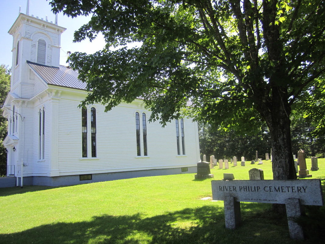
According to the Canada Historic Places Register, an earlier church was built in 1827. The new church at 2808 Wyvern Road was built and dedicated in 1862. According to All Mines and Great Pines, the new site for the church was purchased from John Oxley on May 2, 1871. The deed is posted inside the River Philip United Church. It seemed odd to me that a church would be dedicated in 1862 on land that wasn't purchased until 1871. And it's incorrect; the date on the deed hanging in the church is actually 1817.
On 2 May 1817 in the 57th year of his Majesty's reign John Oxley sold the property for the church to John Black Esquire, Thomas Donkin, Richard Black, Gabriel Purdy Esquire, Thomas Heustis, and Joseph Oxley (Deed Book 6, p. 209, 2 May 1817, Cumberland County, Doc. # 503709079). The property was "part of lot number eleven containing one half acre viz. said land laying on the northwest side of the road leading up River Philip settlement". So the 1817 deed hanging in the church is a deed for the original church and graveyard on Lot 11, not for the current site.
For a deep dive on the deed history and location of the old church, see Lot 11 Yorkshire Grant on this website. Sadly, this beautiful building was destroyed by fire in September of 2022.
According to Andrew P. Barkhouse in All Mines and Great Pines, (1998) the original Methodist church in River Philip was built elsewhere, on land currently owned by Floyd Dickie, and dragged to the new location at 2808 Wyvern Road by oxen. Barkhouse mentioned that gravestones in the original location have disappeared over time.
According to the Canada Historic Places Register, an earlier church was built in 1827. The new church at 2808 Wyvern Road was built and dedicated in 1862. According to All Mines and Great Pines, the new site for the church was purchased from John Oxley on May 2, 1871. The deed is posted inside the River Philip United Church. It seemed odd to me that a church would be dedicated in 1862 on land that wasn't purchased until 1871. And it's incorrect; the date on the deed hanging in the church is actually 1817.
On 2 May 1817 in the 57th year of his Majesty's reign John Oxley sold the property for the church to John Black Esquire, Thomas Donkin, Richard Black, Gabriel Purdy Esquire, Thomas Heustis, and Joseph Oxley (Deed Book 6, p. 209, 2 May 1817, Cumberland County, Doc. # 503709079). The property was "part of lot number eleven containing one half acre viz. said land laying on the northwest side of the road leading up River Philip settlement". So the 1817 deed hanging in the church is a deed for the original church and graveyard on Lot 11, not for the current site.
For a deep dive on the deed history and location of the old church, see Lot 11 Yorkshire Grant on this website. Sadly, this beautiful building was destroyed by fire in September of 2022.
|
|
Location of the Current Church
Originally I thought that the River Philip United Church at 2808 Wyvern Road might be located on Lot 14, originally granted to Methodist minister John Black (1759-1829). The Posterity of William Black, at the beginning of Chapter II, has the following to say about John Black:
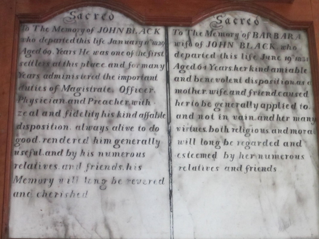
"John Black, as before noticed, was the eldest son of William Black. He married Barbara Donkin, and settled at River Philip. He was a Methodist local preacher, and was always ready to every good work. He secured the assistance of others, and was principal himself, in procuring a grave-yard and a site on which a church was built, mainly by means furnished directly by himself. In this church he used to preach to the inhabitants on Sundays, and industriously worked on his farm during the week. He succeeded in clearing up a large area of intervale and upland, which became, in time, a very valuable farm. He was a Justice of the Peace for Cumberland."
According to the Canada Historic Places website, the River Philip United Church was built over the graves of John Black (1759-1829) and his wife Barbara Donkin (1767-1831). Their gravestones hang inside the church on the wall to the left of the altar. If John Black and his wife had provided the land for the burial ground and were buried on their own Lot 14, it could explain why they might be buried under the church. Or, the gravestones may have been brought to the new location from the old one.
In 1823, John Black mortgaged half of lot 13 and all of lots 14 and 15 to Samuel Cunard in consideration of a debt of 1119 pounds which he was unable to pay. In 1823, John's son James and William Donkin Black paid or assumed the debt and acquired the properties. In 1827, John and William D. Black sold the properties to their brother Amos Black. John Black died in 1829 and his wife Barbara Donkin died in 1831. In 1854, Amos sold half of lot 13 to a Matilda Crane. In 1854, she sold the 1/2 of lot 13 to Hugh MacLellan. Amos had also mortgaged all of the remaining properties to Henry G. Pineo, and in 1856 Henry Pineo sold 1/2 of lot 13 to Hugh MacLellan.
On 11 April 1861, Hugh MacLellan granted 4/5 of an acre to Collingwood C. Oxley, Rufus G. Black, William Smith, and Benjamin Sayre for the purpose of building a Weslyan Methodist Church. The land lay on the "east side of the River Philip Road...commencing at the line between Hugh MacLellan's land and Samuel Bent's land running parallel with the said land eight rods and thence running south 43 degrees east 16 rods thence running in a northerly direction parallel with the road until it strikes the line of Samuel Bent's land and thence along said land to the place of beginning and containing four fifths of an acres more or less." (Hugh McLellan to Charles J. Townshend Deed Book NN, p. 83, Document # 503715299, Registered 1868.). At the time, Samuel Bent owned a small portion of Lot 11 and all of Lot 12, so the church is located near Wyvern Road at the boundary between the original grants 12 and 13. Incidentally, Samuel Bent's son Earl Grey Bent married Hugh McLellan's daughter Amy Jane McLellan. Although some of the stones in the section of the graveyard behind the current church are older than 1861, the deed did not mention an existing church or burial ground. However, since the property was in the possession of the Black family from at least 1823 to 1854, it is certainly possible that a church and burial ground were established earlier.
According to Gwendolyn Ripley, by 1932 George L. King owned John Black's original farm.
