Francis Caleb Smith Homestead
The Homestead of Robert and Isabella Ripley and Francis Caleb Smith
Henry Denny Denson originally obtained a 1000 acre grant on the Nappan River. The property was transferred to Denson's daughter Lucy and her husband Robert Fletcher who later sold the 1000 acres to Thomas Cochran. Robert Ripley and Isabella Bean leased this property from 1782-1803, first from Fletcher and then Cochran. Cochran later leased the property to Michael Keiver from 1808 to 1818. Cochran's daughter Isabella inherited the island property where the Ripley and Keivers had lived and sold it to Frances Caleb Smith. So, the location of the Smith homestead shows us roughly where Robert and Isabella lived within the 1000-acre property. The supporting maps and deed trail are presented below.
Henry Denny Denson originally obtained a 1000 acre grant on the Nappan River. The property was transferred to Denson's daughter Lucy and her husband Robert Fletcher who later sold the 1000 acres to Thomas Cochran. Robert Ripley and Isabella Bean leased this property from 1782-1803, first from Fletcher and then Cochran. Cochran later leased the property to Michael Keiver from 1808 to 1818. Cochran's daughter Isabella inherited the island property where the Ripley and Keivers had lived and sold it to Frances Caleb Smith. So, the location of the Smith homestead shows us roughly where Robert and Isabella lived within the 1000-acre property. The supporting maps and deed trail are presented below.
Mr. Ripley on Thomas Cochran's Map
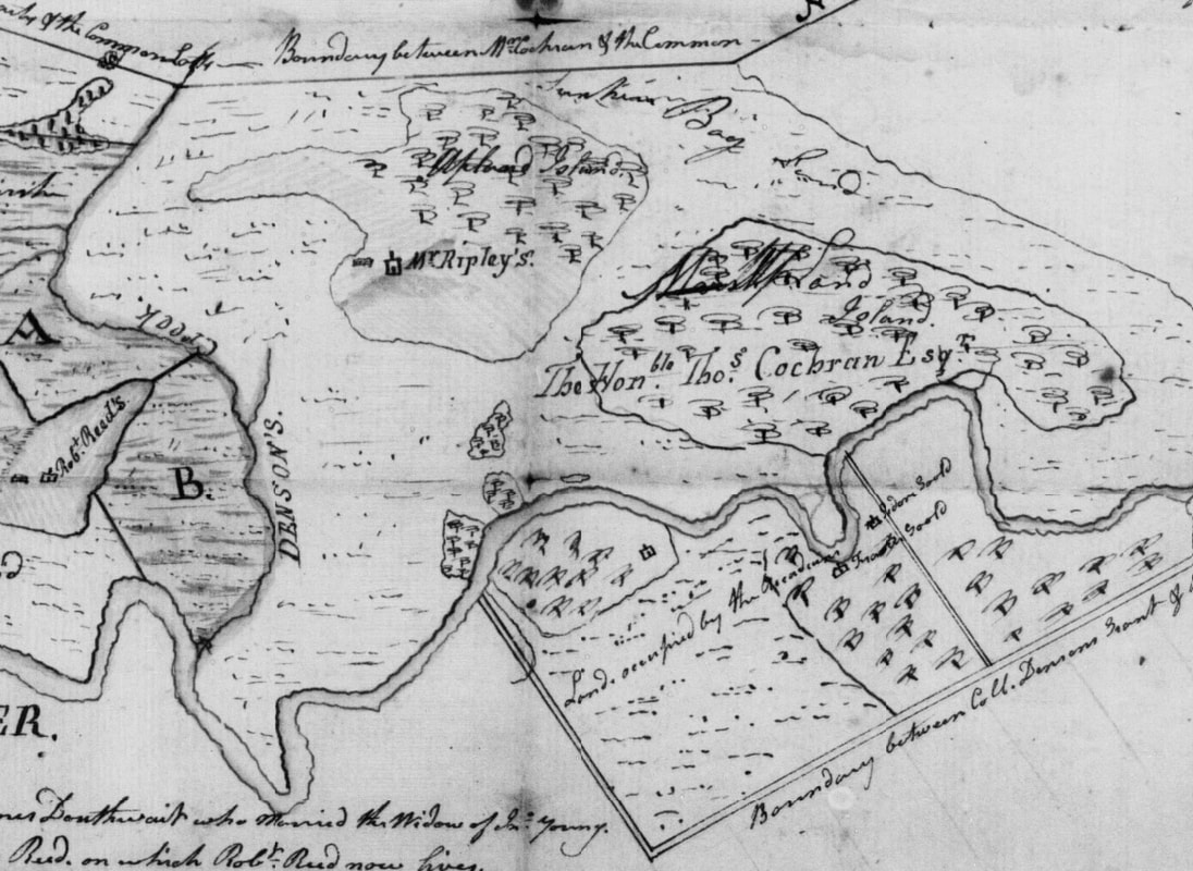
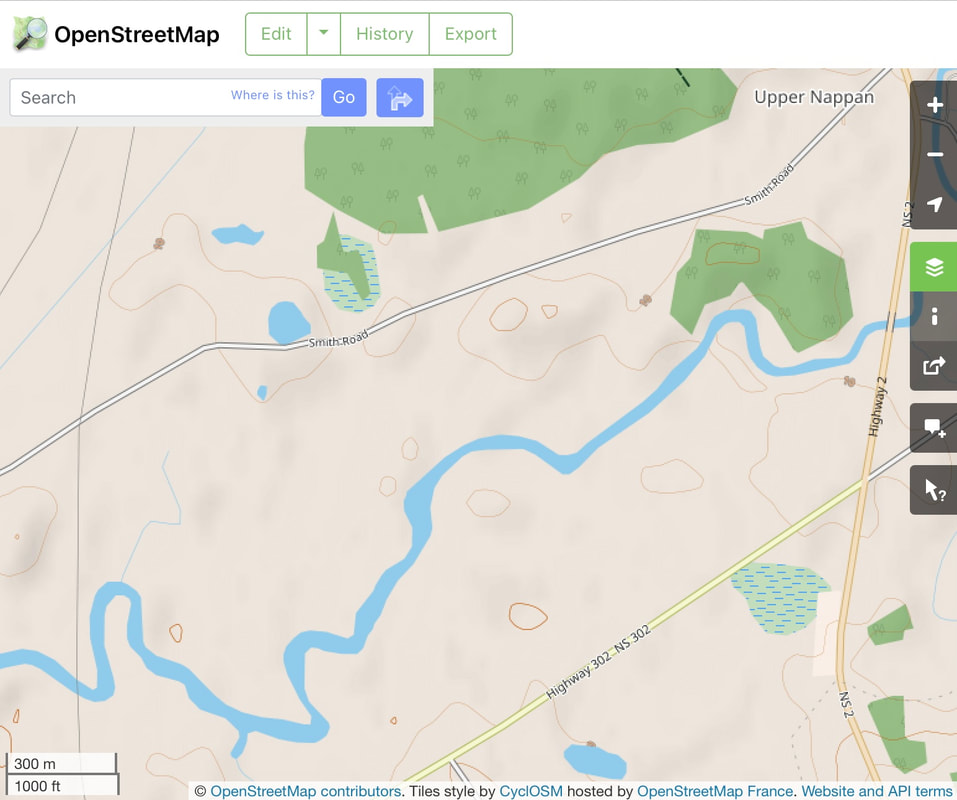
A map of Thomas Cochran's property, made around 1792, can be viewed and downloaded online. (DesBarres Papers, Series 5 M.G. 23, F1-5, Vol. 15 Land acquisitions, 1764-1776; Plans, 1765-1916. Document 2911, Reel C-1458 Image 432.). Robert Ripley was leasing the property at the time the map was made, and the map shows where a Mr. Ripley was living. A section of the Cochran map below shows two islands north of the Nappan River. Mr. Ripley lived on the westernmost island. An Open Street Map view of the same area, shows these two islands outlined in brown contour lines near today's Smith Road.
A map of Thomas Cochran's property, made around 1792, can be viewed and downloaded online. (DesBarres Papers, Series 5 M.G. 23, F1-5, Vol. 15 Land acquisitions, 1764-1776; Plans, 1765-1916. Document 2911, Reel C-1458 Image 432.). Robert Ripley was leasing the property at the time the map was made, and the map shows where a Mr. Ripley was living. A section of the Cochran map below shows two islands north of the Nappan River. Mr. Ripley lived on the westernmost island. An Open Street Map view of the same area, shows these two islands outlined in brown contour lines near today's Smith Road.
|
|
1826 William Hill to Isabella Cochran
Thomas Cochran died in 1801, leaving large amounts of property and no will. In 1826, the estate was finally settled, and the heirs' agent William Hill deeded several properties to Thomas Cochran's daughter Isabella, who later married E B Ramsay. Isabella received the marsh lots Thomas Cochran had purchased from the estate of James Young and a portion of the original Denson Grant. The Denson portion is described as follows: "a certain tract of land being part of the Denson Tract...commencing at a point where the boundary line of the Common Marsh lots intersect the aforesaid Creek, thence Southerly along the courses of the said Creek to the River Nappan, thence easterly along said river until it comes in line with Henry Ripley's house and a birch tree on an island where the buildings now or lately occupied by Michael Keiver stand, thence northerly in a straight course until it comes to the birch tree thence around the upland and the eastern side of the island until it comes to the Common Marsh thence along the line of said marsh to the place of beginning containing one hundred and twelve acres of marsh land, nine and one half acres of sunken marsh and eighty three and a half acres of upland more or less." (Deed Book K, p. 250)
Thomas Cochran died in 1801, leaving large amounts of property and no will. In 1826, the estate was finally settled, and the heirs' agent William Hill deeded several properties to Thomas Cochran's daughter Isabella, who later married E B Ramsay. Isabella received the marsh lots Thomas Cochran had purchased from the estate of James Young and a portion of the original Denson Grant. The Denson portion is described as follows: "a certain tract of land being part of the Denson Tract...commencing at a point where the boundary line of the Common Marsh lots intersect the aforesaid Creek, thence Southerly along the courses of the said Creek to the River Nappan, thence easterly along said river until it comes in line with Henry Ripley's house and a birch tree on an island where the buildings now or lately occupied by Michael Keiver stand, thence northerly in a straight course until it comes to the birch tree thence around the upland and the eastern side of the island until it comes to the Common Marsh thence along the line of said marsh to the place of beginning containing one hundred and twelve acres of marsh land, nine and one half acres of sunken marsh and eighty three and a half acres of upland more or less." (Deed Book K, p. 250)
The Island
Robert Ripley (1734-1797) and Isabella Beane had leased 1000 acres that originally belonged to Henry Denson from 1782 to 1803. Then Michael Keiver (1747-1817) leased the same 1000 acres from 1808 to 1818. The above boundary description was written in 1826. Mr. Keiver lived on an island that bordered the Amherst Common Lots.
Henry Ripley first leased his property on the other side of the Nappan River in 1788, and according to the description, a birch tree on the island is in line with Henry's house. (DesBarres Papers, Series 5 M.G. 23, F1-5, Vol. 15 Land acquisitions, 1764-1776; Plans, 1765-1916. Document 2911, Reel C-1458 Image 432.). I have always wondered why Henry Ripley settled where he did, right in the middle of lands leased by the large extended Gould family. Perhaps it was because he would be directly across the Nappan River from his father's homestead.
1837 Isabella Cochran to Francis C. Smith
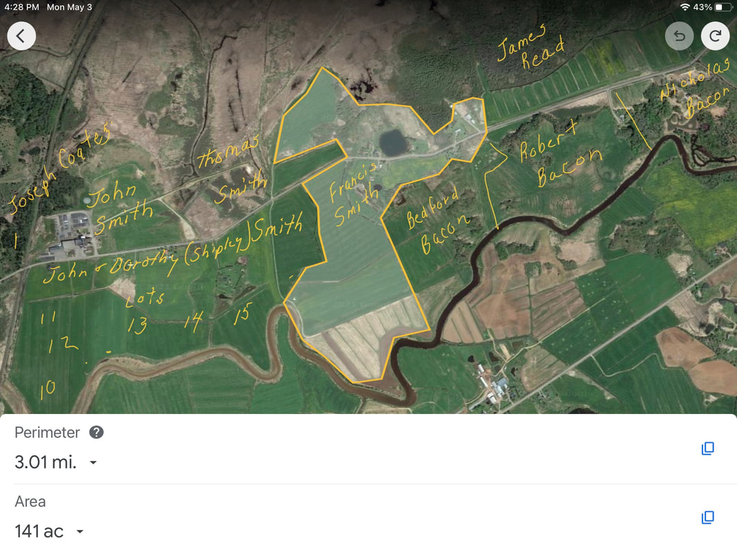
In 1837, Isabella and her husband E B Ramsay sold a portion of the property to Francis Caleb Smith (1808-1866). The property was 85 acres of upland plus 6 lots containing 59 acres 1 rod and 50 poles of adjacent marshland beginning at the birch tree in the above description. The deed includes an entire page of metes and bounds descriptions for the property that change direction 31 times. It appears the surveyor measured around each little nook and cranny of the island. (Deed Book O, p. 362). With the help of a friend who is a surveyor by profession and the Metes and Bounds software, I was able to draw out the property as described in the deed and superimpose it on a map from Google Earth. The farm across the Nappan River at the bottom of the picture was the location of Henry Ripley's original homestead. The boundaries of the property coincide with deed descriptions for adjacent properties owned by Thomas Smith, Bedford Bacon, James Read, etc. See Smith Road: The Moffat Lots on this website for a discussion of the other lots.
In 1837, Isabella and her husband E B Ramsay sold a portion of the property to Francis Caleb Smith (1808-1866). The property was 85 acres of upland plus 6 lots containing 59 acres 1 rod and 50 poles of adjacent marshland beginning at the birch tree in the above description. The deed includes an entire page of metes and bounds descriptions for the property that change direction 31 times. It appears the surveyor measured around each little nook and cranny of the island. (Deed Book O, p. 362). With the help of a friend who is a surveyor by profession and the Metes and Bounds software, I was able to draw out the property as described in the deed and superimpose it on a map from Google Earth. The farm across the Nappan River at the bottom of the picture was the location of Henry Ripley's original homestead. The boundaries of the property coincide with deed descriptions for adjacent properties owned by Thomas Smith, Bedford Bacon, James Read, etc. See Smith Road: The Moffat Lots on this website for a discussion of the other lots.
1848 James Shipley to Francis Caleb Smith
On 5 Jan 1848, James Shipley sold Francis Caleb Smith a portion of the land previously "laid off to Dorothy Smith, widow of John Smith, for her Dower". The parcel included approximately 13 acres of marsh and 30 acres of upland "bounded on the east by a Sunken Creek, on the west by Joseph Coates' land, on the south by lands of William Humphrey and others, and on the north by the remaining part of the lot now in possession of Thomas Smith and his family." (Deed Book U, p. 479). The original property was 91 acres, so Thomas Smith retained 48 acres. See Smith Road: Middle Section on this website for further details on the Shipley property. John Smith and Dorothy Smith were the parents of Francis Caleb Smith.
On 5 Jan 1848, James Shipley sold Francis Caleb Smith a portion of the land previously "laid off to Dorothy Smith, widow of John Smith, for her Dower". The parcel included approximately 13 acres of marsh and 30 acres of upland "bounded on the east by a Sunken Creek, on the west by Joseph Coates' land, on the south by lands of William Humphrey and others, and on the north by the remaining part of the lot now in possession of Thomas Smith and his family." (Deed Book U, p. 479). The original property was 91 acres, so Thomas Smith retained 48 acres. See Smith Road: Middle Section on this website for further details on the Shipley property. John Smith and Dorothy Smith were the parents of Francis Caleb Smith.
1859 James Stewart to Francis Caleb Smith
On 25 Aug 1859, James Stewart sold to Francis Smith the marsh and upland properties "for many years past in possession of the said Francis as tenant." The property was bounded on the south by the "road from Coats Hill past the said Francis Smith's Farm". The property was bordered on the west by uplands belonging to Joseph Coates. On the north, the property was bounded by the marsh of Joseph Coates and Keiver's heirs. On the east the property was bounded by the upland property Francis had purchased from the Cochrans. The purchase included 48 acres of upland and 49 acres of marsh more or less on both sides of McCully's Old Canal. The James Stewart property was made up of 3 properties that Francis's brothers Thomas Smith and John Smith purchased from Isabella (Cochran) Ramsay and sold to Stewart. Originally, the three lots totalled 102 acres, so 5 are not accounted for. (Deed Book DD, p. 221) See Smith Road: North Section for further details on these properties.
On 25 Aug 1859, James Stewart sold to Francis Smith the marsh and upland properties "for many years past in possession of the said Francis as tenant." The property was bounded on the south by the "road from Coats Hill past the said Francis Smith's Farm". The property was bordered on the west by uplands belonging to Joseph Coates. On the north, the property was bounded by the marsh of Joseph Coates and Keiver's heirs. On the east the property was bounded by the upland property Francis had purchased from the Cochrans. The purchase included 48 acres of upland and 49 acres of marsh more or less on both sides of McCully's Old Canal. The James Stewart property was made up of 3 properties that Francis's brothers Thomas Smith and John Smith purchased from Isabella (Cochran) Ramsay and sold to Stewart. Originally, the three lots totalled 102 acres, so 5 are not accounted for. (Deed Book DD, p. 221) See Smith Road: North Section for further details on these properties.
Wills of Francis and Joshua Smith
Francis's son Joshua Smith (1847-1898) inherited the 40 acres of upland known as the homestead farm plus 28 acres of marsh. Alexander Smith received 38 acres of upland and 26 acres of marsh. On the 1873 Church map, A. Smith is shown living beside a pond north of Smith Road and J. Smith is shown just south of the road in the same area. R. Bacon lived to the southwest. So I believe that Alexander and Joshua inherited the property Francis C. Smith purchased from the Cochrans in 1837.
Francis's probate file is viewable online at Family Search. Estate File 1764-1938, No 1983-2021(S), file #2001, beginning at image 668, 1869. Francis left a great deal of property including his homestead of 81 acres upland and 80 acres marsh.
Joshua's probate file is viewable online at Family Search. Estate File 1764-1938, No 1892-1947, file #1937, beginning at image 732, 1898.
Location of the Francis Smith Homestead
A hand-drawn map by Ernest Coates that you can download from Cumberland County Maps on this website, shows the approximate location of the homestead farm #21 on Smith Road across from a small pond and a notation that reads #21 John, Francis, Joshua, Ezra, Janie, sold out now. If anyone connected with this property knows any Smith family stories about old chimneys or homestead foundations, please let me be the first to know!
A hand-drawn map by Ernest Coates that you can download from Cumberland County Maps on this website, shows the approximate location of the homestead farm #21 on Smith Road across from a small pond and a notation that reads #21 John, Francis, Joshua, Ezra, Janie, sold out now. If anyone connected with this property knows any Smith family stories about old chimneys or homestead foundations, please let me be the first to know!
