Original Amherst Township and Gmelin Grants
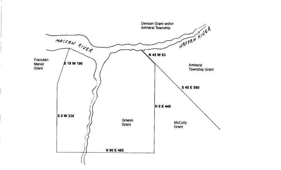
Boundaries of Gmelin and Amherst Grants according to 1772 DesBarres Survey
Grant to Captain Adam Gmelin
On October 12, 1765, Captain Adam Gmelin was granted 20,000 acres on the River Nappan "pursuant to an order of His Majesty in Council dated the Eleventh day of July 1764". Gmelin's grant boundary started "at the northeast corner of Michael Francklin Esq's land, thence running south 18 degrees west 190 chains, thence 336 chains south, thence east 480 chains, thence north 440 chains thence northwest until it meets with the River Nappan. (Old Record Book 6, p. 537.)
A second copy of Gmelin's grant, identified as grant No. 23, was also ordered July 11, 1764 and signed October 12, 1765. Neither the length nor the angle of the boundary shared with Amherst Township was specified in Gmelin's grant. The lack of specificity in the Gmelin and Amherst Township grants led to decades of dispute over the location of the Gmelin line. (Old Record Book 7, p. 61 film #008123371)
Grant to Amherst Township
In 1759, Governor Charles Lawrence had proposed the creation of 13 townships in Nova Scotia. However, it wasn't until October 31, 1765 that John Saunders and others received the first large grant of 26,750 acres within the new Amherst Township. Although the grant named the individual grantees and granted 53 1/2 shares, it did not specify the lot numbers the grantees drew. The 500-acre shares often contained an upland lot, a marsh lot, and a woodlot, called divisions, which were not necessarily located in the same place. No boundaries were specified in the grant. (Record Book 6, p. 561, viewable online at Family Search Nova Scotia Grant registers, film #008123371, Image 287).
A second version of the grant, designated Grant No. 164, was dated October 30, 1765 but not registered until July 9, 1772. According to this version of the grant, the boundary of Amherst Township began at "the north east corner of land granted to Adam Gmelin thence to run south east six miles and seventy chains (of 4 rods each) or until it meets the North Eastern bound of land granted to Alexander McNutt and others thence to run northeast on said land until it meets the sea shore to be bounded northerly by the Township of Cumberland and westerly by the River Des Meine and Napan to the first mentioned bound containing eighty thousand acres more or less." The boundary description, which begins at the existing Gmelin property, suggests that the Gmelin property was actually surveyed first. (Book 8A (9) p. 314, viewable in film #008123371, Image 999)
Samuel McCully et. al. Grant
Although the Gmelin grant and the Amherst Township Grant shared a border that ran southeast from the Nappan River, the Gmelin grant boundary then dropped straight south while the Amherst Grant continued running on a southeast line. The divergence of the two boundary lines created a triangular-shaped property of ungranted Crown land that lay between the Gmelin and Amherst grants. In 1816 this 1350-acre property was granted to Samuel McCully, Thomas Forrest, John Parkinson Pipes, and Robert Oldfield. See Samuel McCully Grant for details. The survey for the 1816 grant re-ignited the dispute over the location of the Gmelin Line.
Although the Gmelin grant and the Amherst Township Grant shared a border that ran southeast from the Nappan River, the Gmelin grant boundary then dropped straight south while the Amherst Grant continued running on a southeast line. The divergence of the two boundary lines created a triangular-shaped property of ungranted Crown land that lay between the Gmelin and Amherst grants. In 1816 this 1350-acre property was granted to Samuel McCully, Thomas Forrest, John Parkinson Pipes, and Robert Oldfield. See Samuel McCully Grant for details. The survey for the 1816 grant re-ignited the dispute over the location of the Gmelin Line.
Continue to Colonel J. F. W. DesBarres
