Lot X and the Boggy Marsh James Read
1826 William Hill to Cochran Heirs
Thomas Cochran died in 1802, but his estate wasn't settled until 1826. At that time, surveyor Thomas Logan created a map of the properties to be sold. I have not been able to locate this map, but I have roughly constructed it from the deeds made by surveyor William Hill to each of the Cochran heirs. And I mean roughly, but you are welcome to have a look. Keep in mind that this map reflects the property at 1826 before the Cochran heirs began to sell their properties. The properties west of today's Hwy 2 were later sold to Francis Caleb Smith in 1837 (northwest section), James Read (northeast section) and Thomas Bacon, (southeast section). cochran_lots_denson_grant.pdf
Thomas Cochran died in 1802, but his estate wasn't settled until 1826. At that time, surveyor Thomas Logan created a map of the properties to be sold. I have not been able to locate this map, but I have roughly constructed it from the deeds made by surveyor William Hill to each of the Cochran heirs. And I mean roughly, but you are welcome to have a look. Keep in mind that this map reflects the property at 1826 before the Cochran heirs began to sell their properties. The properties west of today's Hwy 2 were later sold to Francis Caleb Smith in 1837 (northwest section), James Read (northeast section) and Thomas Bacon, (southeast section). cochran_lots_denson_grant.pdf
1859 James Cochran to James Read
In 1826, agent William Hill deeded Lots X, S, and some of the marsh properties on the Nappan River to William George Cochran as part of his father's estate settlement. In 1859, after William Cochran's death, his brother James sold the 111-acre Lot X plus 150 acres of boggy marsh to James Read (1812-1885). Lot X can be seen on my rough map. The northern boundary was MacDonald Road and a portion of Lot X lay east of today's Hwy 2, but the northwest corner was on the west side of Hwy 2 where it adjoined the Boggy Marsh. In the deed, the property is described as follows: "bounded northerly by the Denson line easterly by Lot V of the Cochran property as will appear by reference to Thomas Logan's plan [see my map above]... westerly by Francis Smith's upland, southerly by the said upland and the farm formerly occupied by Cornelius Smith as tenant and of a line dividing the bog from the mowing marsh of the farm occupied by Mssrs. Keiver and Corbet as tenants being an extension of the south line on the upland to the north end of Indian Island so called subject to a right of way from the road leading past Francis Smith's house towards Indian Island aforesaid on the said Cornelius Smith's farm [probably the angled portion of Smith Road that meets Hwy 2]." (Deed Book G, p. 294)
See Francis Caleb Smith on this website for information about the Smith property that formed the western and southern border of the property James Read purchased. See Thomas Bacon on this website for information on another property that bordered on the south. The farm formerly occupied by Mssrs. Keiver and Corbet as tenants was probably Lot S, purchased by Moses Lowe. In the boundary description, the south line "dividing the bog from the mowing marsh" was probably the south boundary of Lot X, just 16 chains 44 links long compared to the northern boundary of 49 chains 20 links. This is probably part of the angled portion of Smith Road that adjoins Hwy 2.
1867 John W. Read to Thomas Read
In 1867, Thomas Read (1841-1923) paid $40 to his brother John W. Read (1844-1922) to secure the right-of-way for a road to his property. (Book MM, 107). This indicates that James Read had already transferred ownership of some or all of Lot X to his son John W. Read.
In 1867, Thomas Read (1841-1923) paid $40 to his brother John W. Read (1844-1922) to secure the right-of-way for a road to his property. (Book MM, 107). This indicates that James Read had already transferred ownership of some or all of Lot X to his son John W. Read.
1873 A. F. Church Map
The A. F. Church Map shows a T. Read north of the intersection of today's Smith Road and Hwy 2 and a J. R. further to the north on the west side of today's Hwy 2. These were likely James (or John W.) Read and James's eldest son Thomas Read. Thomas Read (1841-1923) and his wife Martha are listed on the 1871 census next to Robert Bacon, who owned a neighbouring property. However, the census documents for 1871, 1881 show that John W. lived with his parents in Fenwick.
The A. F. Church Map shows a T. Read north of the intersection of today's Smith Road and Hwy 2 and a J. R. further to the north on the west side of today's Hwy 2. These were likely James (or John W.) Read and James's eldest son Thomas Read. Thomas Read (1841-1923) and his wife Martha are listed on the 1871 census next to Robert Bacon, who owned a neighbouring property. However, the census documents for 1871, 1881 show that John W. lived with his parents in Fenwick.
1881 John W. Read to Thomas Read
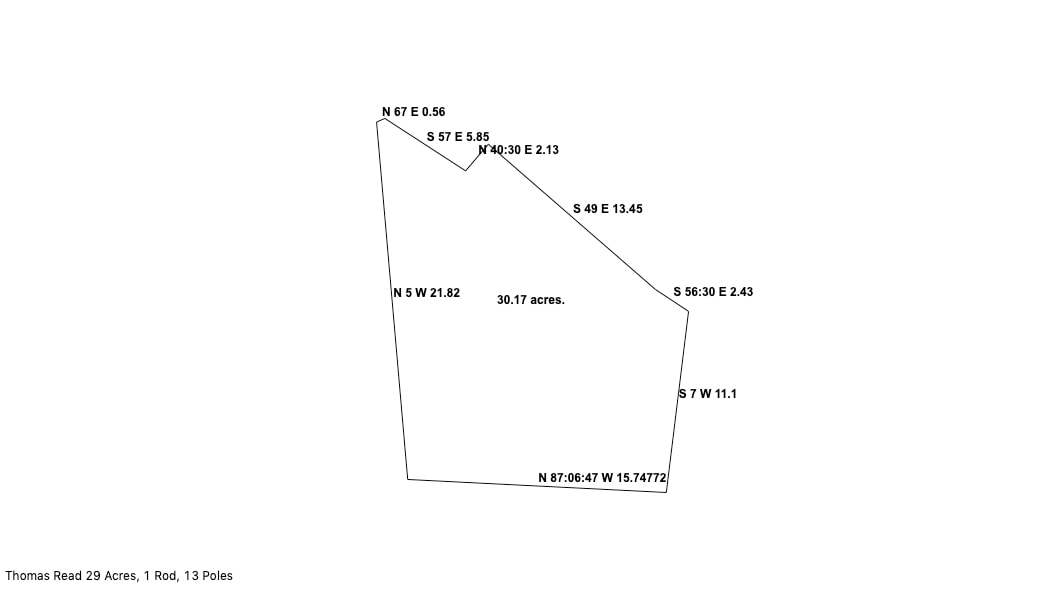
In 1881, John W. Read sold his brother Thomas Read "a part of the bog marsh bought by James Read from Sir James Cochrane...beginning on the north side of the road leading from the said Thomas Read's to Amherst Hill opposite Robert Bacons Road and thence westerly along said road to a stake on the north side opposite a point on Bacon's Island which strikes the road..." (Book 4, p. 327). This property was a little over 29 acres in size and stretched from today's Smith Road north to the Denson Line. The northern boundary ran only 56 links North 67 degrees East on the Denson Line and then jogged south to Smith Road. The same property was conveyed by the heirs of Burton T. Read to Eldon J. Read in 1946 for $1. I have drawn out the lot below, according to the deed. N 5 W 21.82 should be read as "North 5 degrees West 21 chains and 82 links." The bottom line ran along Smith Road and its specific measurements were not given. The line was drawn using a "close figure" option that automatically calculated the distance along Smith Road to complete the drawing.
In 1881, John W. Read sold his brother Thomas Read "a part of the bog marsh bought by James Read from Sir James Cochrane...beginning on the north side of the road leading from the said Thomas Read's to Amherst Hill opposite Robert Bacons Road and thence westerly along said road to a stake on the north side opposite a point on Bacon's Island which strikes the road..." (Book 4, p. 327). This property was a little over 29 acres in size and stretched from today's Smith Road north to the Denson Line. The northern boundary ran only 56 links North 67 degrees East on the Denson Line and then jogged south to Smith Road. The same property was conveyed by the heirs of Burton T. Read to Eldon J. Read in 1946 for $1. I have drawn out the lot below, according to the deed. N 5 W 21.82 should be read as "North 5 degrees West 21 chains and 82 links." The bottom line ran along Smith Road and its specific measurements were not given. The line was drawn using a "close figure" option that automatically calculated the distance along Smith Road to complete the drawing.
1885 Will of James Read
James Read (1812-1885) left his real estate to his son John W. Read in his will. However, it seems that Thomas Read acquired at least 29 acres of the property before his father's death and also acquired additional properties later.
James Read (1812-1885) left his real estate to his son John W. Read in his will. However, it seems that Thomas Read acquired at least 29 acres of the property before his father's death and also acquired additional properties later.
1888 James K. Noiles and Thomas Read Properties on the Denson Line
The probate papers of James K. Noiles contain a fantastic map, made in 1888, that shows the division of Noiles's property on the south margin of what is now Blair Lake The southern border of the Noiles property is marked as the Denson Line and several Read Lots and Thomas Read properties are drawn on the map. This map is viewable online at Family Search. (Nova Scotia Probate Records 1760-1993, Estate Files 1764-1938, no 1483-1534 (M-N), image 126.). The properties belonging to Thomas Read run much longer along the Denson Line than the property he acquired in 1881.
The probate papers of James K. Noiles contain a fantastic map, made in 1888, that shows the division of Noiles's property on the south margin of what is now Blair Lake The southern border of the Noiles property is marked as the Denson Line and several Read Lots and Thomas Read properties are drawn on the map. This map is viewable online at Family Search. (Nova Scotia Probate Records 1760-1993, Estate Files 1764-1938, no 1483-1534 (M-N), image 126.). The properties belonging to Thomas Read run much longer along the Denson Line than the property he acquired in 1881.
The Ernest Coates hand-drawn map of homesteads in this area show a farm #24 north of Smith Road and West of Hwy 2 that belonged to "Thomas, Burton, Eldon Read - Gerald Read, Eldon & Gerald today".
