1816 Samuel McCully Grant
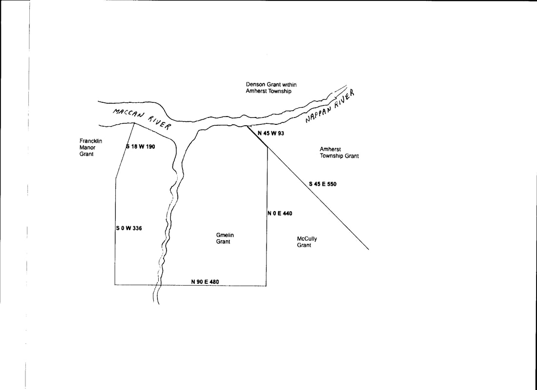
The eastern boundary of the Gmelin grant ran from the Nappan River southeast along the Amherst Township line but then dropped straight south. The Amherst Township line continued on the southeasterly line. The divergence of the two boundary lines created a triangular-shaped property that lay between the two grants. The land in this triangle was not granted until 1816. And since the boundaries of the new grant were the Gmelin and Amherst Township Lines, surveyors would presumably have wanted to assure that the dispute had been resolved. The McCully Grant may have been the reason for the revival of the Gmelin Line dispute in 1814.
1816 Grant of Samuel McCully, Thomas Forrest, John Parkinson Pipes and Robert Oldfield
In 1816, the 1350-acre property was allocated to Samuel McCully, Thomas Forrest, John Parkinson Pipes, and Robert Oldfield. (Book F, p. 81). Samuel McCully received 500 acres, Thomas Forrest 400, John P. Pipes 250, and Robert Oldfield 200 acres. A survey included with the 1816 grant shows the Gmelin line, the Amherst Township Line, and the grants to McCully and the others. (See Family Search Nova Scotia Crown land Grant Registers film #008453640 Image 528-530).
The Amherst Township Boundary of this grant, its eastern boundary, was described as S45E on the survey. This is the same angle that had been described in surveys of the DesBarres property back to 1772 and was also the boundary used on Baker's Old Plan 520. On the McCully survey, the Amherst Township Line comes close to the westernmost point of Lime Kiln Brook but does not cross it as on the Crown Land Index Map. Fenwick Road ran through the McCully grant. The huge grant extended so far south that St. Georges Brook ran through the grants of Pipes and Oldfield. My second great grandfather Andrew C. Ripley owned a grant adjacent to Robert Oldfield's on the south. Andrew's grant was located out on Hwy 2 across from the old Fenwick Mine.
Extreme Gore
The northern section of the McCully et.al. grant, was located north of Fenwick Road. A lot of 45 acres at the very tip of the McCully grant exchanged hands many times. When McCully sold the 45 acres to Alex Milligan in 1824 it was described as "a lot of land ...situated between Gamelial's [sic] eastern line and the westerly line of the Town of Amherst". Alex Milligan and wife Mary sold the property to John Coates in 1833. John Coates and wife Elizabeth mortgaged the lot to Robert Barry Dickey in 1834. In 1858, Thomas Bacon and his wife Matilda sold the 45-acre lot and a neighbouring lot to Thomas Shipley Jr. The property eventually became part of the Porter homestead.
The lot was described as the extreme point or gore of land between lands formerly owned by Governor DesBarres and the Township of Amherst bounded on the north by the lands of George, Louis and Lawrence Gould, on the east by the new road lately made, on the south by William Pipes and John Davidson's lands, and westerly by William Bird. (Book DD, p. 17). The very tip of the gore defined the place where the boundaries between Gmelin's grant and the Amherst Township grant diverged, so it makes sense that the Gould properties lay to the north. Incidentally, if you turn on the "Everything" layer in Google Earth, you can see the old Porter Road that ran along the eastern boundary of the McCully Grant. The property lying to the west, at the time occupied by William Bird, had originally been sold to Peter Noiles. That property eventually became the homestead of Charles Read.
Continue on DesBarres vs Tenants
