Lot S Moses Lowe
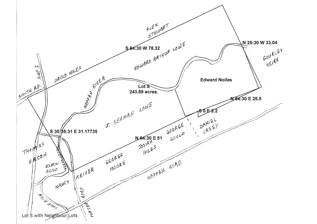
See Upland Lots 70-75 on this website for context. The drawing of Lot S and the Edward Noiles Lot below was made with Metes and Bounds Software. The Nappan River, Hwy 2, Porter Road and neighbouring lots were sketched in. A label such as N25:30 W 33.04 on the map means North 25 degrees 30 minutes West 33 chains and four links. Exact measurements were not given for the western boundary of the lot, so the software's closure tool was used to create the boundary. Sometime between the original sale of Lot S and the sale of 41 acres to Edward Noiles, his southern boundary changed from an angle of 64 degrees 30 minutes to 69 degrees and the eastern boundary from 25 degrees to 21. So the Edward Noiles lot doesn't fit very well within the original dimensions.
The neighbouring lots south of Lot S are listed in the order given on various grants. I don't yet have any information on the size and exact boundaries for these lots. They were most likely the northern portions of the 100-acre lots that stretched south from the Denson Line.
The neighbouring lots south of Lot S are listed in the order given on various grants. I don't yet have any information on the size and exact boundaries for these lots. They were most likely the northern portions of the 100-acre lots that stretched south from the Denson Line.
1826 Thomas Cochran Estate to William Cochran
Lot S was one of the properties transferred to William Cochran by William Hill in 1826 when he divided the estate of Thomas Cochran. The boundaries of Lot S, starting from its SW corner, are described as follows: "commencing at a short distance to the westward of a spruce tree on McGowan's line on the south side of said [Nappan] River thence running North sixty four degrees and 30 minutes east fifty one chains thence south two chains and twenty links thence north sixty four degrees 30 minutes east twenty five chains and fifty links to a poplar tree thence north twenty five degrees and thirty minutes west three [sic]chains and four links to an ash tree thence south sixty four degrees thirty minutes west seventy eight chains and thirty two links to the marsh thence southerly across the river to the place of beginning." According to the deed, the lot contained two hundred and twenty two acres and ten poles of wilderness and seventeen and a half acres of marshland. (Deed Book K, p. 228). The 3 chains north is clearly an error as this measurement needs to be 34 chains and 4 links to match neighbouring lot R on the east. When I drew the lot using the above measurements, the size was calculated as 249.83 acres.
Lot S was bounded on the east by Lot R and on the North by Lots V, W and a small section of Lot X. McGowan's land to the south mentioned in the deed was likely Lot 17 owned by John McGowan. In 1804 John McGowan had sold that 100-acre lot to Michael Keiver Sr. so William Hill wasn't very current on his real estate news.
1859 James Cochran to Moses Lowe
In 1859, after William Cochran's death, James Cochran mortgaged Lot S #7 of the original Denson Grant to Moses Lowe. According to the mortgage boundary description the property was occupied formerly by Edward Noiles and then by Mssrs. Keiver and Corbet as tenants and contained 200 acres of upland, 17 1/2 acres of marsh, plus a piece of marsh of unknown size. (Mortgage and Mortgage Release Deed Book CC, p. 396 and KK, p. 492). Thomas Bacon bought the adjoining property on the west side of today's Hwy 2, and his deed mentions the Messrs. Keiver and Corbet bordering on the east.
In 1871 David Pugsley and his wife Jane sold Moses Lowe 13 1/2 acres of upland and 9 1/2 acres of marsh bounded "on the north and west by the main road leading through Nappan and on the south by lands now in possession of Edward Noiles and east by Beaver Brook." (Deed Book OO, p. 747). This sale confirms that Beaver Brook, aka the Lime Kiln Brook, was outside the boundaries of Cochran's Lot S.
Northern Section: 1868 Moses Lowe to Edward Arthur Lowe
In 1868 Moses Lowe sold 115 acres of Lot S to his son Edward Arthur Lowe. The boundaries are described as follows beginning at the southwest corner of the property, "commencing at the termination of the fence in the River Nappan and Thomas Bacon's land and running along said Bacon's land north west until it comes to Bacon's Road, thence north easterly along said Bacon's Road and crossing the main road and following the south east line of the David Niles farm and Stewarts line until it strikes the northwest line of Amos Gourley's land thence along said Amos Gourley's line southeasterly until it strikes the river thence following the river to the Main Road aforesaid thence following the river to the Bacon land thence up the river to the place of beginning including what is commonly called the Ox Bend containing 100 acres of upland and 15 acres of marsh more or less. "
The boundary commencing at the termination of the fence in the River Nappan was the northernmost point of the Oxbow Bend before it changed from a north/south to an east/west direction. The property line then ran north to Bacon's Road, now Smith's Road, then ran east crossing today's Hwy 2. (Deed Book MM, 624).
The sale reserved a 5-acre piece of property opposite the house of David Niles that Edward Lowe and Erastus Bent purchased in 1875. (Deed Book UU, p. 145). David Noiles owned Lot V from 1862 to 1875; then he sold it to John W. Lowe. See Thomas Bacon on this website for a discussion of the Bacon property that bordered Lot S on the west. Amos Gourley and his sister Annie had acquired the neighbouring Lot R on the east following the death of their father Samuel.
In 1875, Edward Lowe sold 80 acres of Lot S to Bedford Bacon. Bedford Bacon sold Lots V, W, and the 80-acre portion of Lot S to Albert Lawrence in 1884. (Deed Book 10, p. 139). Albert Lawrence later sold properties to his son-in-law Roy Pipes, John Pulk, and Placide Arsenault.
Southeast Section: 1870 Moses Lowe to Edward Noiles
In 1870 Moses Lowe sold 41 acres of the property to Edward Totten Noiles, a former tenant. The boundary is described as follows starting at its northwest corner: "commencing at a stake on the south bank of the Nappan River thence south 21 degrees east 10 chains and 50 links to the northwest angle of lands owned by Daniel Casey's heirs at the Denson Line so called thence along said line north sixty nine degrees east 28 chains and 50 links to land owned by Samuel Gourley's heirs thence north 21 degrees west along said land 16 chains to the Nappan River aforesaid thence down said river its various courses to the place of beginning making 41 acres more or less." (Deed Book WW, p. 157). Samuel Gourley's heirs were his children Amos and Annie to whom he had deeded the property. They owned Lot R at the time.
According to the Noiles property description, the southern boundary of his lot and thus Denson's original grant, extended about 16 chains (about .32 km) south of the Nappan River. This dimension shows that the Denson Line ran parallel to but did not reach Nappan Road. It's odd that the Denson line angle is 69 degrees east as the original angle for Lot S was 64 degrees 30 minutes east. Perhaps it was changed to accommodate the odd jog of the line south. At its southwest corner, Edward Noiles's lot was bordered by the northwest corner of Daniel Casey's heirs.
Southwest Section: 1873 Moses Lowe to J. Seaman Lowe
In January of 1873, Moses Lowe mortgaged a portion of Lot S south of the Nappan River to his son Joseph Seaman Lowe. This property was bounded "on the north and west by the Nappan River, on the east by lands conveyed by said Moses Lowe to Edward Noiles, and on the south by lands of Mrs. Daniel Casey, George Gould, Josiah Niles, George Moore, and Mrs. William Keiver." (Deed Book RR, p. 208). The portion of Lot S bordered by the Nappan on the west and north must be the Ox Bend as it is unusual for the Nappan River to border a property on both the west and north. As explained in the previous section, the southwest corner of the property of Edward Noiles bordered on the northwest corner of Casey's land, so the properties listed as bordering on the Joseph Seaman Lowe mortgage were listed from east to west.
The mortgage, released in January of the same year, also included the 23 acres of upland and marsh Moses Lowe had purchased from David Pugsley in 1871. The size of the main Lot S parcel was not given. (Deed Book 6, p. 25). However, if Lot S originally contained 217 1/2 acres, and 115 had been sold to Edward Arthur Lowe and 41 to Edward Noiles, the Lot S portion was likely about 61 1/2 acres not counting the 23 acres purchased from David Pugsley. However, if Lot S actually contained about 245 acres as my drawing indicated, J. Seaman Lowe's purchase would have been closer to 89 acres.
The neighbouring property of George Moore and the widow Nancy (Jenks) Keiver's dower properties are shown on a plan made of the estate of William Keiver. (Nova Scotia Probate Records, Estate Files 1764-1938, Nos. 1065-1113 (J-K) viewable on Family Search image 721.). It's interesting to note that the Keiver plan also has the Lot S boundary coming in at 69 degrees instead of 64 degrees 30 minutes.
1891 J. Seaman Lowe to Robert Coates
In 1891, J. Seaman Lowe and his wife Ida sold to Robert Coates the 4th, approximately 100 acres of upland and marsh "bounded on the west by the road from Nappan to Amherst and the Nappan River, on the north by the said Nappan River, on the east by lands of E. Totten Noiles, and on the south by the lands of the widow of Daniel Casey, Peter Gould, James Wilson, Robert Coates, and lands purchased by Lowe from George W. Pugsley." (Deed Book 29, p. 423). James Edward Wilson was the heir of Josiah Niles who died in 1881. I do not know whether the road from Nappan to Amherst was today's Hwy 2 or Old Porter Road in 1891. Perhaps Old Porter Road was the road in use and people jogged to the west on Nappan Road a short distance before continuing south. Later, the portion of the road north of Old Porter Road was joined with the southern portion by a new road running west of Old Porter Road. The 15 acres the J. Seaman Lowe acquired from George W. Pugsley were not included in the sale as they are used to define the southern boundary.
In 1891, J. Seaman Lowe and his wife Ida sold to Robert Coates the 4th, approximately 100 acres of upland and marsh "bounded on the west by the road from Nappan to Amherst and the Nappan River, on the north by the said Nappan River, on the east by lands of E. Totten Noiles, and on the south by the lands of the widow of Daniel Casey, Peter Gould, James Wilson, Robert Coates, and lands purchased by Lowe from George W. Pugsley." (Deed Book 29, p. 423). James Edward Wilson was the heir of Josiah Niles who died in 1881. I do not know whether the road from Nappan to Amherst was today's Hwy 2 or Old Porter Road in 1891. Perhaps Old Porter Road was the road in use and people jogged to the west on Nappan Road a short distance before continuing south. Later, the portion of the road north of Old Porter Road was joined with the southern portion by a new road running west of Old Porter Road. The 15 acres the J. Seaman Lowe acquired from George W. Pugsley were not included in the sale as they are used to define the southern boundary.
1903 Robert Coates to Clinton Bacon
In 1903, Robert Coates the 4th and his wife Jane sold the 100 acres that had once belonged to Moses Lowe to Clinton Bacon. (Deed Book 67, p. 329) That property was part of Lot S sold by the Cochran family and part of the original grant to Henry Denny Denson leased by Robert Ripley and Isabella Bean.
I won't take this inquiry any further to respect the privacy of the current owners. Family members and locals will recognize the property. Let's just say that it's been a long search with many bridges to cross but everything's coming up rainbows!
