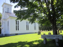
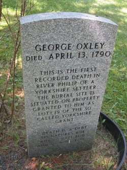
Today I also created a new page on the website about the River Philip Cemetery. While visiting this cemetery I was able to quickly locate the grave of Robert and Isabella's daughter Esther Ripley and her husband Thomas Donkin. When I remarked to Eleanor Ripley-Barrow that the stone was surprisingly clean she told me that the stone was only the second to be cleaned in a restoration project that was just beginning. The W. B. Wells association has given a great deal of assistance for maintenance and restoration of the cemetery and a small local group works hard to preserve their heritage. Many thanks for their efforts which make it possible for people like me to discover their roots. I have included only the handful of graves that are mentioned elsewhere on this website. However, many more are listed in a book of transcriptions by Murray L. Keating for a number of River Philip cemeteries from the Cumberland County Genealogical Society.
2 Comments
I'm home again after a great trip to PEI and will begin adding new information to the website. Today I deciphered some of the deeds I brought back and have made updates and added photos to the pages on the Yorkshire Land Grant 1785, Lots 16 and 17, and Luke Harrison's Farm. I have also created a new page called The Fletcher lease which describes Robert's 1000 acre lease in Amherst. Although the mystery of the locations of Lots 16 and 17 has now been determined, it was a bit disappointing to discover that Robert and Isabella probably never lived at River Philip. I really did love it there. I was very pleasantly surprised to discover that Clair Ripley and Eleanor Ripley-Barrow know quite a bit about the descendants of John Ripley of River Philip as I had previously thought that little was known. Having determined the location of Luke Harrison's farm mentioned in Robert Ripley's will, it now appears that Robert Ripley Jr. and his wife Jane Rushton did live in Southampton. Hopefully their descendants are still in the Southampton area and I will be able to make some contacts there who are as knowledgable about that branch of the Ripley family as Clair and Eleanor are about theirs. I was beyond excited yesterday to finally make contact with newly-found 4th and 5th cousins who are very knowledgable about Ripley history and have been very helpful in clearing up the mystery of George Oxley's grave. Apparently it is true that George Oxley was originally buried elsewhere and then his grave was moved to the River Philip United Church. This matters a great deal because Oxley was buried on Lot 19 and the location of Lot 19 held the key to finding the Ripley Lots 16 and 17. I now believe that the River Philip United Church is at Lot 14 and the Ripley lots are located between the church and the intersection of Windham Hill and Wyvern Roads, the approximate location of Oxley's original burial. Please see the updates I've made to the Yorkshire Grant and Lots 16 and 17 pages on this website. With the aid of a hand-drawn map furnished by Susan Hill, archivist at the Cumberland County Genealogical website, we set off early in the morning to find the Yorkshire Land Grant Plaque and hopefully the original Ripley Land Grants. We took Highway 104 heading southeast from Amherst about 15 minutes to the Oxford Exit number 6. Then we headed south toward Oxford Junction and Collingwood Corner (not north which takes you to Oxford). A short distance past the turn-off to Spring Hill we located the River Philip United Church on the left hand side of the road at 2808 Wyvern Road. After admiring the Classic Revival architecture of the church and wandering through the cemetery nearby, recognizing names very familiar from earlier research, we spotted a boulder and several gravestones in a grove of trees about 50 metres south of the church. This proved to be the location of the Yorkshire Land Grant Plaque and the grave of George Oxley, the first settler to have died in the area. I've updated the Yorkshire Land Grant page on this website with photos taken of the church, the plaque, and George Oxley's grave. On the agenda for a future trip is a visit inside the church to see the history recorded there. I had been quite keen to find George Oxley's grave which, according to the inscription on the new gravestone, was located on his Lot 19 from the Yorkshire Land Grant. Since the Ripley grants are at Lots 16 and 17, locating George's Lot 19 would be very helpful in determining their location. When I mentioned this to Susan Hill, she relayed the disappointing information that an Eleanor Ripley B-something, a resident of River Philip, had told her that George Oxley's remains had previously been buried elsewhere and relocated to the church. I was able to determine Eleanor's last name by asking around town and I'll follow up on that lead before my next trip. Heading south toward Collingwood Corner, we attempted to match up the meanderings of the River Philip with the markings on land grant map number 60 which I had brought along. This was more than a little iffy because it depended on the road being in the same place and the course of the river unchanged since 1785. However, we did find one section where the river did run exactly parallel to the road before veering sharply away as it did on Robert Ripley's Lot 17. I think the reasonable solution to this is a guided flyfishing trip on the river with a guide who knows it well. For example, Danny Ripley at Riptide Flyfishing in Amherst. I didn't see any rising fish but the River Philip is a sweet little river with great-looking lies for trout and it looks reasonable wadable. Property deeds may also be available for the area. In Collingwood Corner, we pulled over to view a lovely pool in the River Philip where locals were swimming to cool off in the heat and nearly tripped over a Ripley Number 4 Road sign lying in the ditch. Flagging down a truck just coming off that road, we learned that the road continued for quite some ways but we were warned that it was fairly rough and we shouldn't attempt it in our rental car. We contented ourselves with wading in the River Philip and reading the rules for fishing etiquette as the swimming hole turned out to be a favourite salmon fishing pool. I've updated the Lots 16,17 page of the website with photos of the River Philip area. We finished the trip with lunch at the Timmy's in Oxford (Tim Horton's was a new experience for my American friend Gail). We took photos with the giant blueberry and bought fresh-picked strawberries from a roadside stand, a gift for Art and Rachel Ripley whom we planned to visit that afternoon. Along with flyfishing, picking blueberries happens to be a favourite activity of mine. I'd certainly say yes to 500 acres on the River Philip. |
AuthorHi there! My name is Mallory Burton and I started researching the Ripley family in 2011. I'd describe myself as a careful amateur who's more interested in story than names and dates. I hope you enjoy my website and blog. I also have a public Mallory/Ripley tree on Ancestry with over 4,000 names. To contact me, please comment on any one of my blog posts. Archives
May 2024
Categories
All
|