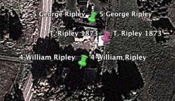
Gord Ripley sent me a fantastic map recently. It was hand drawn by Ernest Coates, a resident of the Amherst area and a well-known local genealogist. The map indicates over 60 homes and farms of early residents of Amherst, Maccan, Nappan, and Fenwick. In addition to the locations, the map provides information about all the previous owners of the properties, going back 5 generations in some cases. The Coates map confirmed previous research I had done and also matched the 1873 A. F. Church map and passages from Myrtle Chappel's book Fenwick 1778-1978. With the new version of Google Earth it has been possible to pinpoint the location of many of the properties and create place marks that include descriptions, links, and photos. By using different colours, I will be able to show current landmarks, the Ernest Coates map, and the 1873 A.F. Church Map. Thanks, Gord. What a fantastic way to explore the area this summer!
 RSS Feed
