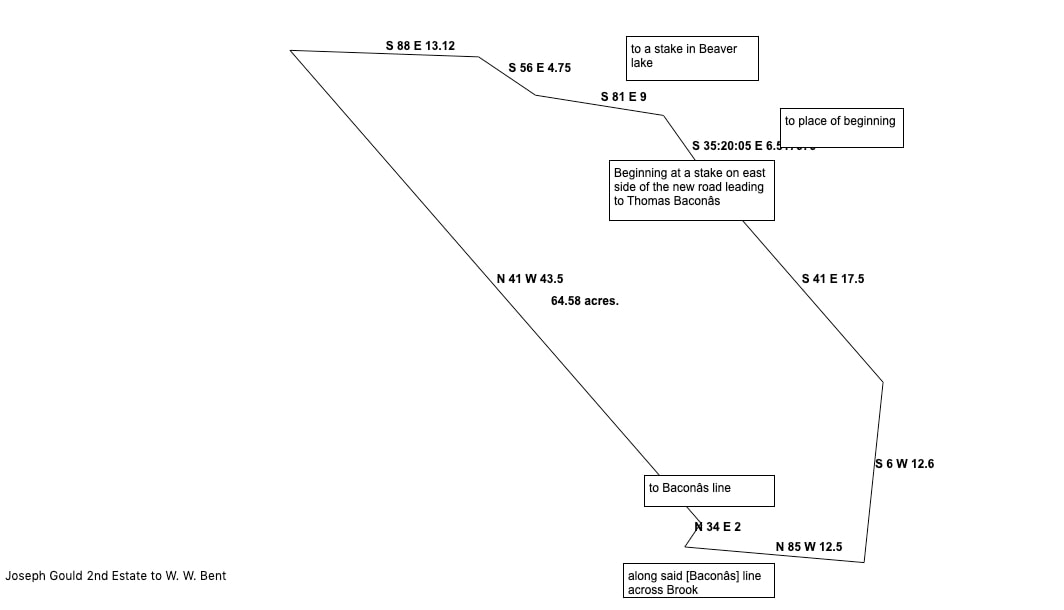
My drawing of Joseph Gould 2nd lot created with Metes and Bounds software.
A 67-acre lot owned by Joseph Gould 2nd lay north of the David Keiver/Thomas Bacon homestead featured in the previous blog post. Joseph Gould 2nd was the son of Jedore Gould. He was known as "the 2nd" to distinguish him from Joseph Gould 1st, son of Francis Gould. The 67-acre lot was one of 4 lots Joseph purchased from Augustus DesBarres. Those lots had previously been part of 400-acre homestead his father Jedore Gould leased from J. F. W. DesBarres.
The Gmelin Line has long been considered the boundary between the DesBarres estate and the Township of Amherst. The line ran southeast from the Nappan River, forming the eastern boundary of the 1816 Samuel McCully Grant. So we would expect that Joseph's 67-acre lot would lie west of the Gmelin Line. Instead, the lot lay east of the Gmelin Line and was bounded on the east by Roach's Line and the property of William Keiver.
DesBarres had settled the Goulds on his estate in 1772. In 1792, Amherst had won a court case alleging the Goulds were settled on Amherst Property. That decision was reversed in 1796 and the Goulds were returned to their lands. At that time a new survey was conducted by Charles Baker. I suspect that when the survey for the 1816 Samuel McCully Grant was undertaken, Baker's survey was found to be in error. However, it seems the Goulds were allowed to remain on their lands.
| joseph_gould_2nd_67-acre_lot.pdf |
 RSS Feed
