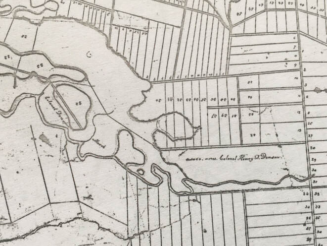
On 1 Oct 1826, the heirs of Thomas Cochran transferred all of the estate property over to William Hill for 5 shillings. And on 2 Oct 1826, William Hill divided up the estate and deeded it back individually to each heir, complete with boundary descriptions. Why do we care? Because the 1000-acre Denson grant that Robert Ripley leased from Fletcher and then Cochran was included in the properties that were devised. Thomas Logan made a survey plan to go along with the dispersals, but I haven't been able to locate it. So instead, I haywired one together, with my limited knowledge of surveying, You're welcome to have a look. This may come in handy if you run into a deed that references Lot R, S, X, V,etc. on the 1826 Thomas Logan plan. cochran_lots_denson_grant.pdf
0 Comments
I am changing my mind about the location of Robert and Isabella's homestead on Denson's 1000-acre lease. Previously I had assumed that the homestead would be located east of Hwy 2 on one of the nice dry upland lots. But I've been taking a very close look at Thomas Cochran's map and now I believe their actual house was located on the west side of today's Hwy 2 north of the Nappan River. Cochran's map shows that Mr. Ripley's house was located on an "island" a local term for a raised area within a marsh. The Amherst Common marsh lots were located north of Mr. Ripley's house so this is definitely on the west side of Hwy 2. After Robert Ripley died and his lease expired, the 1000 acres were leased to Michael Keiver. Michael Keiver died a year before his lease expired in 1818. When Thomas Cochran's estate was settled in 1826, a deed to his son William George Cochran described the location of a Mr. Keiver's house, on an island in the marsh. William Cochran's deed also says that the western boundary of the marsh was a line drawn from a birch tree on that island to Henry Ripley's house. Wow! We know that Henry's house was located at the corner of today's Higgs Road and Nappan Roads on the south side of the Nappan River. Of course, we don't know who "Mr. Keiver" is in the deed since Michael Keiver had died in 1817. But it took from 1802 to 1826 to settle the estate so who knows when the survey was actually done. Do you think it's too much of a stretch to believe, since Robert Ripley and Michael Keiver both leased the same property and lived on islands in the marsh, it was the same house? And that Henry Ripley lived right across the Nappan River from his father? I have finally been able to determine the geographical location of Lot 16 originally drawn by Henry Ripley in the Yorkshire Grant! Henry sold Lot 16 to John Oxley and the property remained in the Oxley family for four generations. In 1911, Howard Ripley acquired the property. I absolutely love that a property that began in Ripley hands returned to Ripley hands. I'd so love to catch a fish or pick a blueberry on that property! For a really deep dive into the deeds and wills see Sale of Lot 16 on this website.
I've done a really deep dive on the deed history of Lot 11 of the Yorkshire grant. This was the site of the courthouse and the original Methodist church in River Philip. See River Philip United Church on this website.
I recently (okay, yesterday) discovered that the New Brunswick County Deed Registry Books 1780-1930 are available online at Family Search for free and at Ancestry by subscription. It took me all afternoon to figure out how to use them, so I made an instruction page and put it on this website under Resources. Check out New Brunswick Deeds 1780-1930
Please let me know whether you have success following these instructions or if you have suggestions for improvement. Happy searching! I'm so happy that I touched based this week with Sandy Wilbur, who has done extensive work on the McCully family. Sandy sent me a list of the deeds he had for Samuel McCully, and on the list was an 1802 deed from Samuel McCully to Thomas Coates for a 500-acre property in Sussex Parish New Brunswick on Smith Creek. My 4th great grandfather Thomas Coates is buried at Smiths Creek near Sussex NB. So I realized this was likely the homestead Thomas Coates relocated to in 1804 after selling his Nappan farm to Samuel McCully. I was even happier to discover that the New Brunswick deeds are online and available at Ancestry. I had no idea that when I visited Smiths Creek and took photos of Smiths Creek, Salmon Creek, picturesque farms and covered bridges, that I was probably walking around and driving through some of Thomas's homestead. I have updated the Homestead at Smiths Creek page on this website with the new information. I was thrilled to learn that the River Philip Church will not be torn down and that my research on the church's original and current locations may have played a small part in saving the church. I have recently created separate pages for my research on the church and research on Lots 16 and 17 of the Yorkshire Grant. A few years ago, several past owners of Lot 11, where the original church was located, participated in a discussion on the Pictorial History of Oxford FaceBook group, sharing what they knew about the history of the property. I have summarized the information from that discussion in the new page, River Philip United Church. Today I discovered something that has been right under my nose all along. Henry Denny Denson's grant, which Robert Ripley leased, consisted of 5 lots of upland numbered 70-75 and 5 marsh lots also numbered 70-75. I thought that all of this property straddled the Nappan River and lay east of the highway. However, today I was taking a closer look at a map of the Amherst Town Lots I found in the Ernest Coates map file, and I noticed that Henry Denson's grant was marked on it. Then, to the west of his grant, was a long strip of marsh on the north side of the Nappan River labeled "Colonel Denson's Marsh". The marsh extended so far west on the Nappan River it would have been opposite the properties of the Goulds, Henry Ripley, and possibly even George Noils.
Then I had another look at the map Thomas Cochran made of the property after he acquired it from Denson's daughter. Sure enough, there's the "marshland of Thomas Cochran" extending far to the west of the rest of the grant. I had looked at it before and assumed that marsh was a separate property Cochran had acquired. Here's a link to view the map online. I've been tearing my hair out trying to figure out how a property that Thomas Bacon purchased from Cochran's descendants could be bordered on the south and east by the Nappan River and on the west and south by Francis Smith. But this would make sense if the property was west of the highway. |
AuthorHi there! My name is Mallory Burton and I started researching the Ripley family in 2011. I'd describe myself as a careful amateur who's more interested in story than names and dates. I hope you enjoy my website and blog. I also have a public Mallory/Ripley tree on Ancestry with over 4,000 names. To contact me, please comment on any one of my blog posts. Archives
May 2024
Categories
All
|