The Keiver Properties
The 100-acre Lots
The 100-acre lots, located south of the Nappan River, were very valuable lots in Amherst Township. One of the lots bordered the river and the others lay directly south of the Denson Grant, a 1000-acre property within Amherst Township. In 1764, Josiah Throop laid out both the 1000-acre Denson grant and the 100-acre lots. In a 1796 court case over the location of the Gmelin Line, he was called as a witness. Throop testified that he had laid out the lots beginning at Denson's southeast corner at Cobequid Road. From Cobequid Road to the Ox Bend of the Nappan River, he had laid out lots 7 to 16. Then, from the Ox Bend for a further 70 chains to an oak tree, he had laid out lots 17 to 23. (DesBarres Papers Series 5 M.G. 23 F1-5 Vols. 19-20 Document 4091, Reel C-1469, Image 462.)
While Troop's testimony is very clear, it doesn't match the layout of these lots on either of the early plans I have seen. These plans show Lot 20 opposite the Ox Bend and a block of lots running east/west adjacent to Cobequid Road. What's interesting is that Michael Keiver purchased Lots 15, 16 and 17 and Lot 17 is exactly where Throop said it should be, opposite the Ox Bend. Charles Stuart, Keiver's neighbour to the east, occupied Lot 14. Keiver's homestead became the westernmost property on the Amherst Township Line. I have not yet been able to determine what happened to 100-acre lots 18-23 that should have been located west of Keiver. Instead, that area was occupied by DesBarres tenants, the Goulds.
At the 1831 court case between Augustus DesBarres and the Goulds, a relative of John McGowan, who had originally sold Lot 17 to Michael Keiver, was called as a witness. William McGowan testified that his uncle, son of John McGowan, had once shown him lands claimed by McGowan that were within the DesBarres tract. The uncle had told the witness that "he never would acknowledge DesBarres line as long as he could help it." DesBarres Papers, Series 5 (M.G. 23, F1-5, Vol. 25) Estate Papers and suits, 1824-1857 Reel C-1461, #6337, image 168).
Estate of Michael Keiver
In 1804, Michael Keiver Sr. had purchased the 100-acre Lot 17 from John McGowan (Deed Book F, p. 169). In 1805, Keiver acquired the neighbouring 100-acre Lots 16 and 15 from Thomas Forrest (Deed Book F, p. 170). This is the same Michael Keiver who leased the Denson Grant after Robert Ripley's lease ended. Keiver and his family were living on the Denson property when he died in 1817, a year before his lease expired. In his will, Keiver left his 300-acre farm in Amherst, then rented to a Jeremiah Casey, to his widow Margaret. When his three youngest sons, Joseph, Michael, and John, had all turned 21, they were to divide the farm and care for their mother. But that isn't exactly what happened.
In 1804, Michael Keiver Sr. had purchased the 100-acre Lot 17 from John McGowan (Deed Book F, p. 169). In 1805, Keiver acquired the neighbouring 100-acre Lots 16 and 15 from Thomas Forrest (Deed Book F, p. 170). This is the same Michael Keiver who leased the Denson Grant after Robert Ripley's lease ended. Keiver and his family were living on the Denson property when he died in 1817, a year before his lease expired. In his will, Keiver left his 300-acre farm in Amherst, then rented to a Jeremiah Casey, to his widow Margaret. When his three youngest sons, Joseph, Michael, and John, had all turned 21, they were to divide the farm and care for their mother. But that isn't exactly what happened.
Sons of Michael Keiver
In 1835, John Keiver sold his 1/3 interest in his father's farm to his brothers Nicholas and Michael (Deed Book O, p. 510). In 1835, William also mortgaged his share to his brother Nicholas. However, in 1842, Nicholas Keiver and his wife Isabella of Shepody in Westmoreland County New Brunswick sold the property, now 350 acres, back to William Keiver. In 1842, Michael Keiver sold a moiety, or undivided half-interest, in the entire 350 acres to Robert Pugsley. This is why you see 4 Pugsley lots on the Wm. Keiver estate plan. (Deed Book R, p. 90).
The property description shows that William's property lay directly south of the Cochran property Lot S but extended a bit west to the mouth of Lime Kiln Brook (Beaver Lake Brook). Charles Stewart owned 100-acre Lot 14 on the east. William Keiver's property "began at the west angle of a lot of land owned by Charles Stewart, thence south sixty four degrees thirty minutes west twenty one chains and eighty links to a spruce tree, thence following the course of the old fence as it [unreadable] westerly to the River Nappan thence down the River westerly until it meets the outlet of Beaver Lake Brook thence up the various windings of said Brook southerly until it meets the boundary line of lands now in possession of Francis Gould thence south thirty nine degrees east seven chains to the edge of the upland thence along the edge of the upland easterly twenty five links, thence south forty four degrees east fifty five chains to a birch tree thence due south fourteen chains to the rear line of said tract, thence north sixty four degrees 30 minutes east thirty four chains or until it meets the south angle of lands owned by Charles Stewart thence north twenty five degrees thirty minutes west until it meets the place of beginning."
I have drawn it out below, roughing in the boundaries that are not precise and estimating the length of the boundary with Charles Stewart.
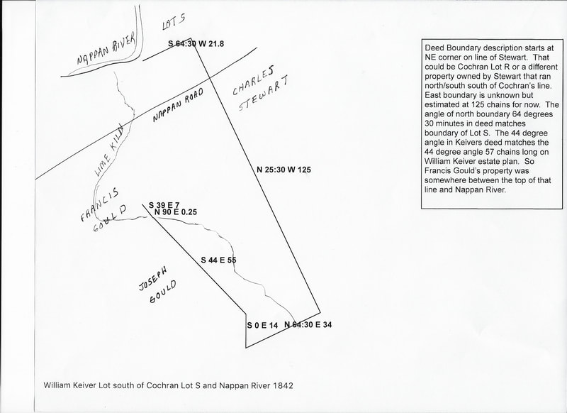
The bearing of Keiver's northern property boundary "south sixty four degrees thirty minutes" is exactly the angle given for the southern boundary of Cochran's Lot S which bordered Keiver on the north. William Keiver's property reached the Nappan River at the Ox Bend where the river abruptly changes course to a more northerly direction. The boundary then continued to Beaver Lake Brook, today's Lime Kiln Brook, before continuing south to Francis Gould's property. From Francis Gould, the boundary continued south forty four degrees east. That angle is roughly parallel to the "south forty five degrees east" bearing that was the northeast boundary of the Gmelin grant. A forty four degree east angle is shown on the William Keiver estate plan. This is the Roach Line mentioned in the Gould deeds that was said to be the new dividing line between DesBarres and Amherst.
In 1846, William Keiver acquired a 50-acre parcel from Thomas B. Gould and his wife Elizabeth. Thomas had purchased the property from Francis Thomas Gould and the property had been previously occupied by Francis Bartlet Gould. This property was "bounded easterly by the lands of the said William Keiver, northerly by the main road, westerly by lands owned by George Gould, Louis Gould, and Lawrence Gould, southerly by lands of Joseph Gould, and southwesterly by eleven acres of marsh, today laid off and surveyed for the said Thomas B. Gould, lying to the southwest of an old creek running through the marsh." This was a property, part of which lay west of the 44 degree Roach line, that was partially enclosed by Lime Kiln Brook at its westernmost point.
In 1846, William Keiver acquired a 50-acre parcel from Thomas B. Gould and his wife Elizabeth. Thomas had purchased the property from Francis Thomas Gould and the property had been previously occupied by Francis Bartlet Gould. This property was "bounded easterly by the lands of the said William Keiver, northerly by the main road, westerly by lands owned by George Gould, Louis Gould, and Lawrence Gould, southerly by lands of Joseph Gould, and southwesterly by eleven acres of marsh, today laid off and surveyed for the said Thomas B. Gould, lying to the southwest of an old creek running through the marsh." This was a property, part of which lay west of the 44 degree Roach line, that was partially enclosed by Lime Kiln Brook at its westernmost point.
Estate of William Keiver
William died in 1860 without leaving a will. His probate papers include a very detailed drawing of his remaining property. Most of these properties are east of Lime Kiln Brook. The Dower Lot of his widow Nancy Keiver adjacent to the Moore [George B. Moir] property indicated on the map lay south of Cochran's Lot S. The irregular lines that come in at a 69 degree angle in the northeast corner of the plan and then jog up are likely the fence mentioned in the 1842 deed from Nicholas to William Keiver. (Nova Scotia Probate Records, Estate Files 1764-1938, Nos. 1065-1113 (J-K) viewable on Family Search image 721.) A second map on image 736 and a written description of the allocation of the properties beginning on image 745 are very useful in sorting out these properties as they mention neighbouring properties not shown on the maps.
On the west side of the estate plan is a line angled N44W that abruptly stops in the middle of a Keiver property in the westernmost bend of the Lime Kiln Brook. This is the Roach Line, which replaced the Gmelin Line in defining the boundary between DesBarres and the Amherst Township. According to Crown Land Index Map 59, the Gmelin Line (dotted line) crossed the west most bend of Lime Kiln Brook, so I believe the Gmelin Line is correctly drawn on the Index Map. On the Index Map, the Gmelin Line crosses just south of the Hwy2/Nappan Road intersection. However, if you put a straight edge along the Roach Line on the William Keiver estate plan, the Roach Line crosses on or slightly north of the intersection. The Roach Line was definitely east of the Gmelin line; a 67-acre lot purchased by Joseph Gould was bounded by the Gmelin Line on the west and the Roach Line on the east. (See The Gould Properties on this website for details.)
Further Research
Some of the properties in Michael Keiver's original homestead were acquired by J. Seaman Lowe and sold to Burton Thomas Read in 1919. These properties later became the homesteads of Price Read and Charles Read. Other portions of the original homestead were acquired by David Pugsley and later by David's son George W. Pugsley. These and other properties allocated from William Keiver's estate became the homesteads of Allison Styles, Gordon Bacon, Walton Bacon, Albert E. Lawrence, and others. I am currently working on detailed summaries for the dispersal of the Keiver Estate.
Some of the properties in Michael Keiver's original homestead were acquired by J. Seaman Lowe and sold to Burton Thomas Read in 1919. These properties later became the homesteads of Price Read and Charles Read. Other portions of the original homestead were acquired by David Pugsley and later by David's son George W. Pugsley. These and other properties allocated from William Keiver's estate became the homesteads of Allison Styles, Gordon Bacon, Walton Bacon, Albert E. Lawrence, and others. I am currently working on detailed summaries for the dispersal of the Keiver Estate.
Continue on Fenwick Crossroads Lots
